Hillsboro in Marion County, Kansas — The American Midwest (Upper Plains)
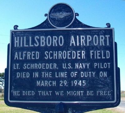
Hillsboro Airport
Alfred Schroeder Field
Lt. Schroeder U.S. Navy pilot died in the line of duty on March 29, 1945
"He died that we might be free"
Topics. This memorial is listed in these topic lists: Air & Space • War, World II.
Location. 38° 20.873′ N, 97° 12.893′ W. Marker is in Hillsboro, Kansas, in Marion County. Memorial is on D Street, on the left when traveling west. Touch for map. Marker is in this post office area: Hillsboro KS 67063, United States of America. Touch for directions.
Other nearby markers. At least 8 other markers are within 5 miles of this marker, measured as the crow flies. A Place of Meditation (approx. 0.4 miles away); Veterans Memorial (approx. 0.4 miles away); Replica of the Statue of Liberty (approx. 0.4 miles away); The Crossing of Historic American Trails (approx. half a mile away); First Mennonite Church (approx. 0.6 miles away); Alexanderfeld Village (approx. 1.1 miles away); Ebenfeld Centennial (approx. 4.7 miles away); Frantz L. Groening (approx. 5.1 miles away). Touch for a list and map of all markers in Hillsboro.
Also see . . . M66 Alfred Schroeder Field. (Submitted on November 11, 2012, by William Fischer, Jr. of Scranton, Pennsylvania.)
Credits. This page was last revised on January 5, 2021. It was originally submitted on November 11, 2012, by William Fischer, Jr. of Scranton, Pennsylvania. This page has been viewed 446 times since then and 13 times this year. Photos: 1, 2, 3. submitted on November 11, 2012, by William Fischer, Jr. of Scranton, Pennsylvania.


