Near Sharpsburg in Washington County, Maryland — The American Northeast (Mid-Atlantic)
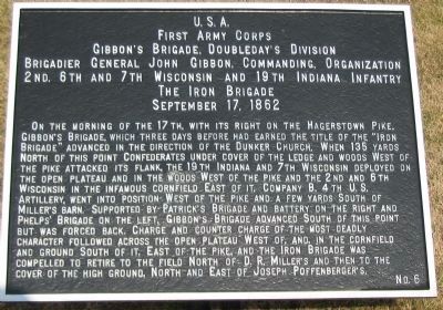
First Army Corps
Gibbon's Brigade, Doubleday's Division
First Army Corps
Gibbon's Brigade, Doubleday's Division
Brigadier General John Gibbon, Commanding, Organization
2nd, 6th and 7th Wisconsin and 19th Indiana Infantry
The Iron Brigade
September 17, 1862
On the morning of the 17th, with its right on the Hagerstown Pike, Gibbon's Brigade which three days before had earned the title of the "Iron Brigade" advanced in the direction of the Dunker Church. When 135 yards North of this point Confederates under cover of the ledge and woods West of the pike attacked its flank, the 19th Indiana and 7th Wisconsin deployed on the open plateau and in the woods West of the pike and the 2nd and 6th Wisconsin in the infamous cornfield East of it. Company B, 4th U.S. Artillery, went into position West of the pike and a few yards South of Miller's barn. Supported by Patrick's Brigade and battery on the right and Phelps' Brigade on the left, Gibbon's Brigade advanced South of this point but was forced back. Charge and counter charge of the most deadly character followed across the open plateau West of, and, in the cornfield and ground South of it, East of the pike, and the Iron Brigade was compelled to retire to the field North of D.R. Miller's and then to the cover of the high ground, North and East of Joseph Poffenberger's.
Erected by Antietam Battlefield Board. (Marker Number 6.)
Topics and series. This historical marker is listed in this topic list: War, US Civil. In addition, it is included in the Antietam Campaign War Department Markers series list. A significant historical month for this entry is September 1812.
Location. 39° 28.848′ N, 77° 44.921′ W. Marker is near Sharpsburg, Maryland, in Washington County. Marker is at the intersection of Starke Avenue and Dunker Church Road, on the right when traveling west on Starke Avenue. Touch for map. Marker is in this post office area: Sharpsburg MD 21782, United States of America. Touch for directions.
Other nearby markers. At least 8 other markers are within walking distance of this marker. 124th Pennsylvania Volunteer Infantry (a few steps from this marker); New Jersey State Monument (within shouting distance of this marker); Jackson's Division, Jackson's Command (within shouting distance of this marker); 13th New Jersey Infantry (within shouting distance of this marker); Indiana State Monument (within shouting distance of this marker); a different marker also named Jackson's Division, Jackson's Command (within shouting distance of this marker); Massachusetts State Monument (within shouting distance of this marker); Twelfth Army Corps (within shouting distance of this marker). Touch for a list and map of all markers in Sharpsburg.
Also see . . .
1. Antietam Battlefield.

Photographed By Craig Swain, February 9, 2008
2. War Department Tablet 6 and 124th Pennslyania Monument
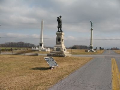
Located at the intersection of Starke Avenue and Dunker Church Road. In the background are the Indiana (left) and New Jersey (right) State Monuments. The cornfield to the northeast corner of the intersection.
2. 4th Brigade, 1st Division, I Corps. Private John Johnson, of Company D, 2nd Wisconsin received the Medal of Honor with the citation referencing two battles - Antietam and Fredericksburg. Here at Antietam, he volunteered to serve a gun of Battery B, 4th U.S. Artillery, remaining at his position with enemy infantry nearly overrunning the piece. (Submitted on March 11, 2008, by Craig Swain of Leesburg, Virginia.)

Photographed By Craig Swain, February 9, 2008
3. Gibbon's Brigade Deploys
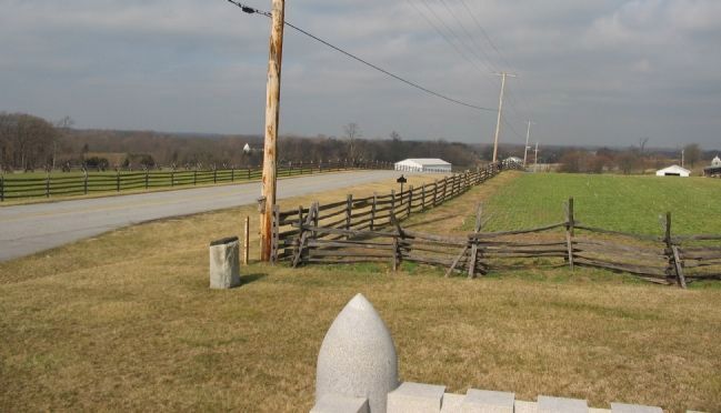
Looking north from the Indiana State Monument, the Old Hagerstown Pike (Dunker Church Road) runs north from the left of frame. The Brigade began deploying in reaction to Confederate fire about where the road drops off in the center of the photo. Two regiments deployed to the west (left side) of the pike and two on the east.
Credits. This page was last revised on September 29, 2017. It was originally submitted on March 11, 2008, by Craig Swain of Leesburg, Virginia. This page has been viewed 937 times since then and 16 times this year. Photos: 1, 2, 3. submitted on March 11, 2008, by Craig Swain of Leesburg, Virginia.
