Cherokee Indian Reservation in Swain County, North Carolina — The American South (South Atlantic)
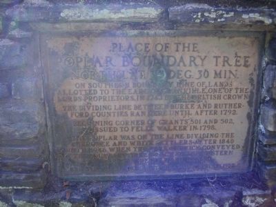
Place of the Poplar Boundary Tree
North Lat. 35 Deg. 30 Min.
Inscription.
on Southern Boundary Line of lands allotted to the earl of Granville, one of the lords proprietors, in 1743 by the British Crown.
The dividing line between Burke and Rutherford counties ran here until after 1792.
Beginning corner of grants 501 and 502, issued to Felix Walker in 1798.
The poplar was on the line dividing the Cherokee and White settlers after 1840 until 1946 when the park service conveyed the boundary tree trace to the Eastern Band of the Cherokee Indians
Erected 1952 by Cherokee Historical Association.
Topics. This historical marker is listed in these topic lists: Native Americans • Political Subdivisions • Settlements & Settlers. A significant historical year for this entry is 1743.
Location. 35° 29.995′ N, 83° 18.691′ W. Marker is in Cherokee Indian Reservation, North Carolina, in Swain County. Marker is on U.S. 441 near Bureau of Indian Affairs Highway 1411. Touch for map. Marker is in this post office area: Cherokee NC 28719, United States of America. Touch for directions.
Other nearby markers. At least 8 other markers are within walking distance of this marker. Sorghum Cane (approx. 0.9 miles away); Broomcorn (approx. 0.9 miles away); Sorghum Mill and Furnace (approx. 0.9 miles away); Springhouse (approx. one mile away); Apple House (approx. one mile away); Corn Cribs (approx. one mile away); The Meathouse (approx. one mile away); Hogs (approx. one mile away).
Credits. This page was last revised on June 16, 2016. It was originally submitted on April 13, 2009, by Stanley and Terrie Howard of Greer, South Carolina. This page has been viewed 1,259 times since then and 13 times this year. Last updated on November 29, 2012, by Don Casada of Bryson City, North Carolina. Photos: 1, 2. submitted on April 13, 2009, by Stanley and Terrie Howard of Greer, South Carolina. • Bill Pfingsten was the editor who published this page.

