
La Vieille Eglise
(The Old Church)
this page online
(Translated by Google Translate with modifications:)
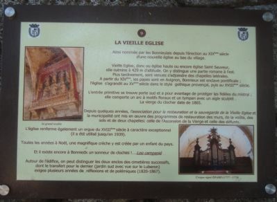
The Old Church
Called by the Bonnieulais since the nineteenth century erection of a new church at the bottom of the village.
Old church or high church or Saint Sauveur, it culminates at 429 m altitude. It is distinguished by being partly Romanesque on the east side. Later, it came to be joined by its side chapels. From the XIVth century, the popes in Avignon, Bonnieux was a papal enclave, the church expands in the XVth century in the Gothic style of Provence, and the eighteenth century.
The original entrance is south gate and has the advantage of protecting the faithful from the mistral and includes a floral arch and a tympanum with a carved eagle. The Blessed Virgin of the bell tower dates from 1865.
In recent years, the association for the restoration

Erected by Mairie de Bonnieux. (Marker Number 9.)
Topics. This historical marker is listed in this topic list: Religion & Religious Structures. A significant historical year for this entry is 1865.
Location. 43° 49.39′ N, 5° 18.55′ E. Marker is in Bonnieux, Provence-Alpes-Côte d'Azur (Provence-Alps-French Riviera), in Vaucluse. It can be reached from Rue du Castelas. Touch for map. Marker is in this post office area: Bonnieux, Provence-Alpes-Côte d'Azur 84480, France. Touch for directions.

Regionally, it is in the North Atlantic Region, Europe, the European Union, Atlantic Europe, the Schengen Area, Western Europe, a coastal Mediterranean country, and the Western World. Historically, it finds itself in what was once a French colony, the Roman Empire, and specifically the Holy Roman Empire.
Other nearby markers. At least 8 other markers are within walking distance of this marker: Belvedere (within shouting distance of this marker); Escaliers Emile Gardon (within shouting distance of this marker); Bonnieux (within shouting distance of this marker); Rue Droite (about 90 meters away, measured in a direct line); a different marker also named Rue Droite (about 90 meters away); Ancien Hotel de Ville ou Hotel de Rouvil (about 90 meters away); Place du Moulin a Huile (about 150 meters away); Rue Voltaire (about 150 meters away). Touch for a list and map of all markers in Bonnieux.
Credits. This page was last revised on September 12, 2018. It was originally submitted on December 11, 2012, by Barry Swackhamer of Brentwood, California. This page has been viewed 589 times since then and 39 times this year. Photos: 1, 2. submitted on December 11, 2012, by Barry Swackhamer of Brentwood, California. • Bill Pfingsten was the editor who published this page.
