Lowndesboro in Lowndes County, Alabama — The American South (East South Central)
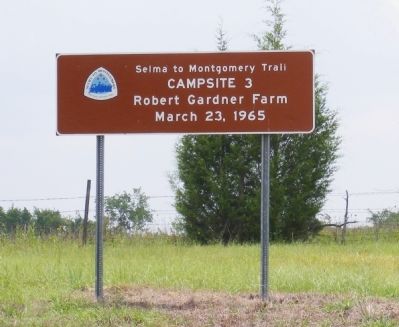
Campsite 3
Selma to Montgomery Trail
March 23, 1965
Erected by National Park Service, U.S. Department of the Interior.
Topics and series. This historical marker is listed in these topic lists: African Americans • Civil Rights. In addition, it is included in the African Methodist Episcopal (AME) Church, and the Unitarian Universalism (UUism) series lists. A significant historical month for this entry is March 1863.
Location. 32° 16.139′ N, 86° 32.184′ W. Marker is in Lowndesboro, Alabama, in Lowndes County. Marker is at the intersection of Frederick Douglass Road and U.S. 80, on the left when traveling south on Frederick Douglass Road. Touch for map. Marker is in this post office area: Lowndesboro AL 36752, United States of America. Touch for directions.
Other nearby markers. At least 8 other markers are within 5 miles of this marker, measured as the crow flies. Shiloh Primitive Baptist Church (approx. 1.8 miles away); Elmore Bolling (approx. 3.1 miles away); History of the Lowndesboro School (approx. 4.2 miles away); Our Confederate Soldiers (approx. 4.2 miles away); CME Church (approx. 4.3 miles away); Lewis-Smith Cemetery (approx. 4.3 miles away); Lewis-Smith Historic Cemetery (approx. 4.3 miles away); Lowndesboro, Alabama / Lowndesboro Business District (approx. 4.4 miles away). Touch for a list and map of all markers in Lowndesboro.
Regarding Campsite 3. National Park Service
Selma to Montgomery March
Until 1965, counties in Alabama used preventive measures in order to prevent African-Americans from registering to vote. Because of this, only 2% percent of the African-American population of Dallas County at that time was able to vote and 0% in Lowndes County. However, civil rights activists began to protest in Selma in order to bring attention to this injustice. These protests were often met by violence from the local sheriff's department, leaving many wondering what was going to happen next.
On the evening of February 18, 1965 during a protest to free SCLC supporter Rev. James Orange from the Perry County Jail, located in Marion, AL, Jimmie Lee Jackson was shot in the abdomen. Jackson died from his wounds on February 26.
On March 7, approximately 600 non-violent protestors, the vast majority being African-American, departed from Brown Chapel A.M.E. Church in Selma with the intent on marching 54-miles to Montgomery, as a memorial to Jimmy Lee Jackson and to protest for voter's rights. As they crossed the Edmund Pettus Bridge on March 7, they were met by a column of State Troopers and local volunteer officers of the local sheriff's department who blocked their path. The non-violent protesters were told by Maj. John Cloud that they had two minutes to return back to their church and homes. In less than the time allotted, they were attacked by the Law Enforcement Officers with nightsticks and teargas. According to several reports, at least 50 protestors required hospital treatment. The brutality that was displayed on this day was captured by the media; however, the media was held back as the protesters retreated, where the violence continued for some time.
The attack caused outrage around the country, and March 7 became known as "Bloody Sunday". Two days later, Dr. Martin Luther King Jr. led a second march which again had its path blocked by Law Enforcement Officers. This time they decided to turn back and not risk a violent confrontation. However, that evening, three Unitarian ministers who had traveled to Selma in order to join the protest were attacked by a group of white hooligans. On March 11, Rev. James Reeb, died from his injuries.
The civil rights protestors sought and received an injunction for a third march, which was granted by Judge Frank M. Johnson, Jr. on March 17. On March 21 the official Selma to March began with the final number of supports reaching near 25,000 people on March 25. Five months later, President Lyndon B. Johnson signed the Voting Rights Act which prohibits discrimination in voting practices or procedures because of race and color.
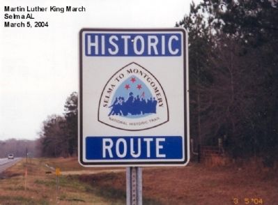
The Selma to Montgomery National Historic Trail was created by an act of Congress in 1996. The National Park Service operates the Lowndes County Interpretive Center, the first of three planned centers. It is halfway between Selma and Montgomery and is on the site of the original “Tent City”.
Related markers. Click here for a list of markers that are related to this marker.
Also see . . . Map of the Selma to Montgomery Trail. (Submitted on October 26, 2020, by Byron Hooks of Sandy Springs, Georgia.)
Credits. This page was last revised on April 19, 2024. It was originally submitted on December 15, 2012, by Don Morfe of Baltimore, Maryland. This page has been viewed 1,020 times since then and 56 times this year. Photos: 1, 2. submitted on December 15, 2012, by Don Morfe of Baltimore, Maryland. • Craig Swain was the editor who published this page.
Editor’s want-list for this marker. A wide shot of the marker and its surroundings. • Can you help?

