Near Aurora, Western Cape, South Africa — Southern Africa
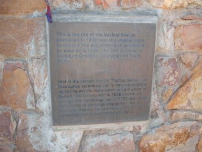
Arc of the Meridian
Topics. This historical marker is listed in this topic list: Science & Medicine. A significant historical year for this entry is 1838.
Location. 32° 41.901′ S, 18° 28.72′ E. Marker is near Aurora, Western Cape. Marker is on Pastorie Street, on the left when traveling north. Touch for map. Marker is in this post office area: Aurora WC 7325, South Africa. Touch for directions.
Regarding Arc of the Meridian.
Abbé Nicolas Louis de la Caille was born in France in 1713. He was sent to South Africa in 1751 to determine the shape of the earth. The English scientists of the day believed the earth was flat at the poles, while the French believed it was oblong. On account of his work in France he was sent to the Cape to prove the theory of the French.
While at the Cape he measured the distance from earth to Mars (and arrived at the value 131 500 000 km). He had to measure the arc of meridian to establish the shape of the earth and determine the exact longitude of Cape Town – this he did by observations of the satellites of Jupiter. He also charted the positions of nearly 10 000 stars in the southern hemisphere and gave names to constellations.
The Arc of Meridian
“The Arc of the Meridian is an imaginary line on the meridian (runs true North - South), drawn anywhere on earth. The Scientific value of such a line is that, if the line is long enough (at least 70 km (43.4 mile)) and surveyed with great accuracy, then the curvature of the earth can be measured. Add to that principle the accurate measurement of the latitudes (how far north or south you are from the equator) at the two far ends of the line, and you measure the distance of the line by independent means to the physical measurement. This gives you an extra value to test measurement against. In other words: you can measure the curvature of the Earth, and more than that, the size and shape of the Earth.” (Copied with gratitude from: www.saao.ac.za/assa/html/his-astr_-_lacaille.html)
The Work of La Caille
The Northern point for his measurements of the arc of meridian that he selected was Klipfontein, a farm in the mountains north of Piquetberg. His fundamental baseline, which was eight miles long [12.8km], was measured on the Darling Flats, using wooden rods. On this base, by observations of angles, he built a series of triangles connecting his Strand Street observatory to Capocberg, not far from Darling, Riebeek Kasteel and Klipfontein. The true distance between Klipfontein and Strand Street (the north and south stations) could now be established by calculation. La Caille then made astronomical observations to fix the latitude difference between the two stations. He came to the conclusion that the earth was PEARSHAPED – the southern hemisphere being the fatter part of the pear. His calculations proved to be wrong due to a 10 cm error on the tape that he used in his measurements. He was proven wrong in 1838 by the astronomer Maclear – his conclusion: the earth is round! Read more on the website: www.saao.ac.za/assa/html/his-astr_-_lacaille.html
Credits. This page was last revised on June 16, 2016. It was originally submitted on March 5, 2013, by Tom de Roo of Cape Town, South Africa. This page has been viewed 884 times since then and 43 times this year. Photos: 1, 2. submitted on March 5, 2013, by Tom de Roo of Cape Town, South Africa. • Bill Pfingsten was the editor who published this page.

