Columbus in Bartholomew County, Indiana — The American Midwest (Great Lakes)
Atterbury Army Air Field
Photographed by Duane Hall, March 15, 2013
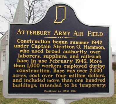
1. Atterbury Army Air Field Marker (Front)
(Front Side)
Construction begun summer 1942 under Captain Stratton O. Hammon, who used broad authority over laborers, suppliers, and railroad; base in use February 1943. More than 1,000 workers employed during construction. Base was over 2,000 acres, cost over four million dollars, and included more than one hundred buildings, intended to be temporary.
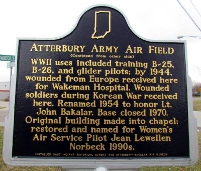
(Back Side)
WWII uses included training B-25, B-26, and glider pilots; by 1944, wounded from Europe received here for Wakeman Hospital. Wounded soldiers during Korean War received here. Renamed 1954 to honor John Bakalar. Base closed 1970. Original building made into chapel; restored and named for Women's Air Service Pilot Jean Lewellen Norbeck 1990s.
Erected 2007 by Indiana Historical Bureau and Atterbury-Bakalar Air Museum. (Marker Number 03.2007.2.)
Topics and series. This historical marker is listed in these topic lists: Air & Space • Religion & Religious Structures • War, Korean • War, World II. In addition, it is included in the Indiana Historical Bureau Markers series list. A significant historical month for this entry is February 1943.
Location. 39° 15.068′ N, 85° 53.696′ W.
this page online

Regionally, this marker is in Southern Indiana. It is also in the American Midwest and in the Corn Belt. Globally, it is in North America, the Western Hemisphere, the Western World, and the Anglosphere. Historically, it finds itself in what was once the territory of the Mississippian Culture and also the Northwest Territory.
Other nearby markers. At least 8 other markers are within 4 miles of this marker, measured as the crow flies: Patriot Burials (approx. 1.6 miles away); Orinoco Furniture Company (approx. 2½ miles away); a different marker also named Patriot Burials (approx. 3 miles away); Votes for Women (approx. 3.1 miles away); Second Baptist Church (approx. 3.1 miles away); Cerealine Manufacturing Company (approx. 3½ miles away); First Christian Church (approx. 3½ miles away); Bartholomew County Civil War Memorial (approx. 3.6 miles away).
Photographed by Duane Hall, March 15, 2013
2. Atterbury Army Air Field Marker (Back)
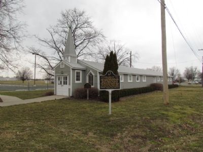
Regarding Atterbury Army Air Field. The following information is provided on the door of the chapel:
This historic building is the Jeanne Lewellen Norbeck Memorial Chapel. The Jeanne Lewellen Norbeck Memorial Chapel is a restored 1942 barracks building converted to a chapel during the Korean War. The chapel is dedicated to the memory of Jeanne Lewellen Norbeck a Women Air Force Service Pilot during WWII. On October 16, 1944 a week after her last visit to Columbus, she was killed instantly when the BT-13 Vultee Valiant airplane she was piloting crashed. The restored chapel was dedicated on Friday, May 29, 1998.
Also see . . . IHB Annotations. The Indiana Historical Bureau provides annotations for the text of the marker on their website. (Submitted on March 18, 2013, by Duane Hall of Abilene, Texas.)
Photographed by Duane Hall, March 15, 2013
3. Jeanne Lewellen Norbeck Memorial Chapel
Photographed by Duane Hall, March 15, 2013
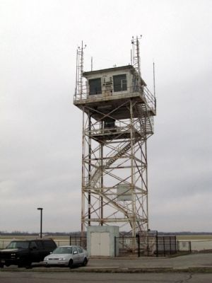
4. Atterbury Army Air Field Control Tower
Credits. This page was last revised on June 16, 2016. It was originally submitted on March 18, 2013, by Duane Hall of Abilene, Texas. This page has been viewed 1,015 times since then and 37 times this year. Photos: 1, 2, 3, 4. submitted on March 18, 2013, by Duane Hall of Abilene, Texas. • Bill Pfingsten was the editor who published this page.
