Jerusalem, Jerusalem District, Israel — The Middle East (West Asia)
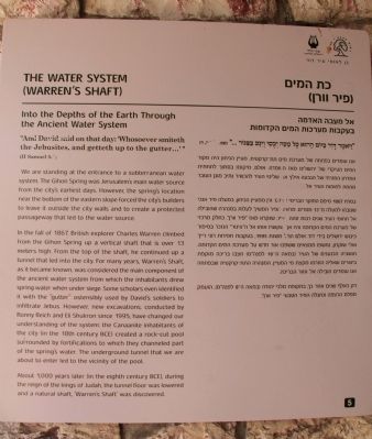
The Water System
(Warren's Shaft)
— Into the Depths of the Earth Through the Ancient Water System —
"And David said on that day: 'Whosoever smiteth the Jebusites, and getteth up to the gutter...'" (II Samuel 5:8)
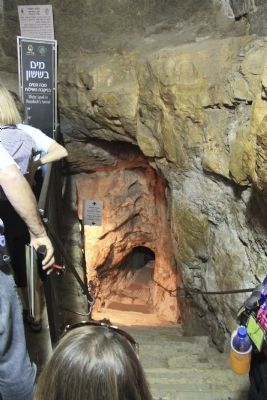
We are standing at the entrance to a subterranean water system. The Gihon Spring was Jerusalem's main water source from the city's earliest days. However, the spring's location near the bottom of the eastern slope forced the city's builders to leave it outside the city walls and to create a protected passageway that led to the water source.
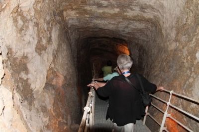
In the fall of 1867, British explorer Charles Warren climbed from the Gihon Spring up a vertical shaft that is over 13 meters high. From the top of the shaft, he continued up a tunnel that led into the city. For many years, Warren's Shaft, as it became known, was considered the main component of the ancient water system from which the inhabitants drew spring water when under siege. Some scholars even identified it with the "gutter" ostensibly used by David's soldiers to infiltrate Jebus. However, new excavations, conducted by Ronny Reich and Eli Shukron since 1995, have changed our understanding of the system, the Canaanite inhabitants of the city (in the 18th century BCE) created a rock-cut pool surrounded by fortifications to which they channeled part of the spring's water. The underground tunnel that we are about to enter led to the vicinity of the pool.
About 1,000 years later (in the eighth century BCE), during the reign of the kings of Judah, the tunnel floor was lowered and a natural shaft, 'Warren's Shaft' was discovered.
Topics and series. This historical marker is listed in this topic list: Settlements & Settlers. In addition, it is included in the City of David Tour series list. A significant historical year for this entry is 1867.
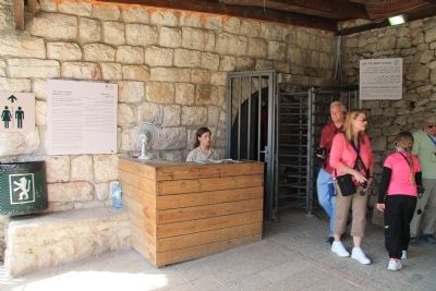
Location. 31° 46.387′ N, 35° 14.176′ E. Marker is in Jerusalem, Jerusalem District. Marker can be reached from Ma'alot Ir David Street just east of Ma'ale HaShalom, on the left when traveling south. This historical marker is located just off of the roadway, inside the "City of David - Ancient Jerusalem" facility, which offers visitors a tour of both historic and archaeological sites that are part of the Ancient City of David. It is situated at Stop Five of the City of David historic tour route, which is at the entrance to the water system tour. Touch for map. Touch for directions.
Other nearby markers. At least 8 other markers are within walking distance of this marker. The House of Ahiel (within shouting distance of this marker); The Burnt Room and the House of the Bullae (within shouting distance of this marker); The Large Stone Structure (about 90 meters away, measured in a direct line); The Royal Quarter (Area G) (about 90 meters away); Beit Hatzofeh Lookout (about 120
meters away); Two superposed vaulted rooms (about 210 meters away in Israel); The Gate House (about 210 meters away in Israel); Structures from First Temple period, Second Temple period, and Byzantine period (about 210 meters away in Israel). Touch for a list and map of all markers in Jerusalem.
Regarding The Water System. The "City of David - Ancient Jerusalem" handout/brochure has this to say about the Warren Shaft System stop on the historic tour:
"And the king and his men went to Jerusalem against the Jebusites, the inhabitants of the land ... David took the stronghold of Zion; the same is the city of David. And David said on that day: 'Whosoever smiteth the Jebusites, and getteth up to the gutter ...' (2 Samuel 5: 6-8)"
"The Gihon Spring, which issues close to the foot of the eastern slope of the City of David, has always been Jerusalem's main water source. Because it is so low down, however, the builders of the city had to leave it outside the city walls. In the autumn of 1867, British explorer Captain Charles Warren discovered an underground tunnel that burrowed beneath the city walls and led to a 13-meter deep shaft. For many years
the shaft, known since as Warren's Shaft, was considered to be the main component of the ancient city's water system from which the inhabitants drew spring water when under siege. Some scholars identified the shaft with the 'gutter' ostensibly used by David's soldiers, to infiltrare Jebus.
"From 1995 on, following the excavations of Ronny Reich and Eli Shukron, remains have been uncovered that significantly change our understanding of the ancient water system. In the 18th century BCE, the Canaanite inhabitants of the city hewed a large pool in the rock near the Gihon Spring and surrounded it with fortifications. The inhabitants descended to the fortified pool, which was outside the city walls, through the secret tunnel discovered by Warren, to draw their water safely, protected by the massive fortifications. Only about 1,000 years later, in the eighth century BCE, was the floor level of the tunnel lowered for unknown reasons, revealing the existence of a natural (karstic) shaft. It is now apparent that the shaft fulfilled no function in the Canaanite water system."
Related markers. Click here for a list of markers that are related to this marker. To better understand the relationship, study each marker in the order shown.
Also see . . .
1. City of David. This is a link to information provided by the "City of
David - Ancient Jerusalem" website. (Submitted on March 27, 2013, by Dale K. Benington of Toledo, Ohio.)
2. Gihon Springs. This is a link to information provided by a website entitled Jerusalem 101. (Submitted on March 27, 2013, by Dale K. Benington of Toledo, Ohio.)
3. Warren's Shaft. This is a link to information provided by Wikipedia, the free encyclopedia. (Submitted on March 27, 2013, by Dale K. Benington of Toledo, Ohio.)
Credits. This page was last revised on May 18, 2023. It was originally submitted on March 27, 2013, by Dale K. Benington of Toledo, Ohio. This page has been viewed 1,427 times since then and 21 times this year. Photos: 1, 2, 3, 4, 5. submitted on March 27, 2013, by Dale K. Benington of Toledo, Ohio.
