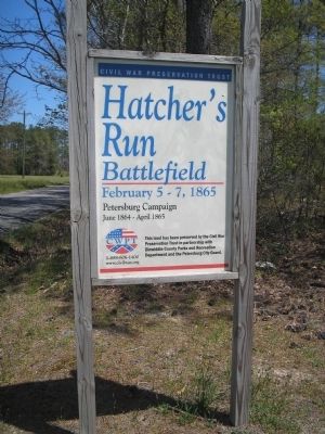
Near Burgess in Dinwiddie County, Virginia — The American South (Mid-Atlantic)
The Battle of Hatcher’s Run
Fighting Around Dabney’s Sawmill, February 6-7, 1865
Inscription.
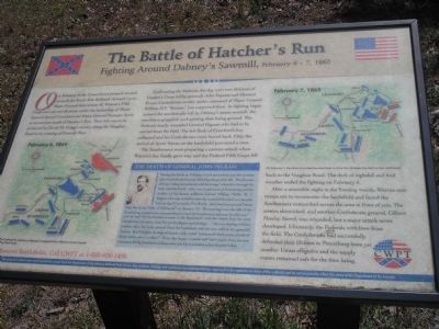
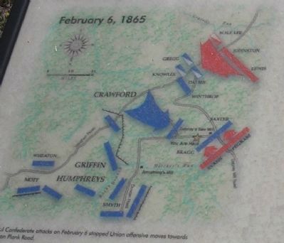
On February 6, the Union forces pressed onward towards the South Side Railroad. Around 1 p.m., Major General Gouverneur K. Warren’s Fifth Corps sent out two divisions under the leadership of Major General Samuel Crawford and Major General Romeyn Ayres to reconnoiter south of Hatcher’s Run. Their left was to be protected by David M. Gregg’s cavalry along the Vaughan Road at its crossing of Gravelly Run.
Confronting the Federals this day were two divisions of Gordon’s Corps led by generals John Pegram and Clement Evans. Confederate cavalry under command of Major General William H.F. “Rooney” Lee supported them. As fighting began around the sawdust pile left by Dabney’s steam sawmill, the two forces grappled, each gaining then losing ground. The Federals fatally wounded General Pegram who had to be carried from the field. The left flank of Crawford’s line collapsed and his Confederates were forced back. Only the arrival of Ayres’ forces on the battlefield prevented a rout.
The Southerners were preparing a counter-attack when Warren’s line finally gave way and the Federal Fifth Corps fell back to the Vaughan Road. The dark of nightfall and foul weather ended the fighting on February 6.
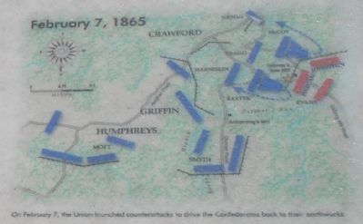
After a miserable night in the freezing woods, Warren sent troops out to reconnoiter the battlefield and found the Southerners entrenched across the area in front of you. The armies skirmished, and another Confederate general, Gilbert Moxley Sorrel, was wounded, but a major attack never developed. Ultimately, the Federals withdrew from the field. The Confederates had successfully defended their lifelines to Petersburg from yet another Union offensive and the supply routes remained safe for the time being.
(Sidebar):The Death of General John Pegram.
During the battle on February 6 and somewhere near the sawdust pile, Confederate General John Pegram gave his life. The 33-year-old was "riding immediately with his troops" when shot through the body near his heart. John was a native son of Petersburg and the brother of the famed artillerist Colonel William “Willie” R.J. Pegram who also would be mortally wounded less than two months later on April 1 at nearby Five Forks. John had just married Hettie Cary the lovely "belle of Richmond" on January 19. The marriage was the talk of the Confederate capital as he was considered "one of the handsomest and most lovable men" ever to wed "the handsomest woman in the Southland – with her classic face, her pure complexion, her auburn hair, her perfect figure and carriage…" She was staying with her mother when his body arrived from the battlefield and she was told of the general’s demise. Kyd Douglas, its original bearer, sadly noted "a fiancée of three years, a bride of three weeks, now a widow!" Even this happy occasion and brief respite from the war weariness felt by Southern civilians came quickly to a fateful end at Hatcher’s Run.
Erected by Civil War Preservation Trust.
Topics. This historical marker is listed in this topic list: War, US Civil. A significant historical month for this entry is January 1922.
Location. 37° 7.481′ N, 77° 29.819′ W. Marker is near Burgess, Virginia, in Dinwiddie County. Marker is on Dabney Mill Road (Virginia Route 613), on the right when traveling east. Located in the 50 acre Hatcher's Run Battlefield preservation tract. Touch for map. Marker is in this post office area: Burgess VA 22432, United States of America. Touch for directions.
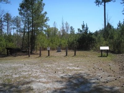
Other nearby markers. At least 8 other markers are within 2 miles of this marker, measured as the crow flies. Brigadier General John Pegram (here, next to this marker); a different marker also named The Battle of Hatcher’s Run (a few steps from this marker); a different marker also named Battle of Hatcher’s Run (within shouting distance of this marker); Hatcher's Run Battlefields (approx. 1.4 miles away); a different marker also named Hatcher's Run Battlefields (approx. 1.4 miles away); a different marker also named Hatcher's Run Battlefields (approx. 1½ miles away); a different marker
also named Hatcher's Run Battlefields (approx. 1.7 miles away); Quaker Road Engagement (approx. 1.7 miles away). Touch for a list and map of all markers in Burgess.
More about this marker. The marker contains two battle maps. On the lower left is a map of the action on February 6, 1865, with the caption Successful Confederate attacks on February 6 stopped Union offensive moves towards the Boydton Plank Road.The upper right of the marker has a map of the action on February 7, 1865, with the caption On February 7, the Union launched counterattacks to drive the Confederates back to their earthworks.The sidebar contains a portrait of General Pegram.
Regarding The Battle of Hatcher’s Run. The marker was placed by the Civil War Preservation Trust, and displays their slogan, Help Preserve Battlefields, call CWPT at 1-888-606-1400. At the bottom of the marker is a disclaimer, This material is based upon work assisted by a grant from the Department of the Interior, National Park Service. Any applications, findings and conclusions or recommendations expressed in this material are those of the author(s) and do not necessarily reflect the views of the Department of the Interior.
Also see . . .
1. Hatcher's Run. National Park Site. (Submitted on March 23, 2008, by Bill Coughlin of Woodland Park, New Jersey.)
2. Battle of Hatcher’s Run. Civil War Preservation Trust. (Submitted on March 23, 2008, by Bill Coughlin of Woodland Park, New Jersey.)
3. Hatcher's Run. Feb 5-7. The Civil War Siege of Petersburg. (Submitted on December 21, 2008, by Bill Coughlin of Woodland Park, New Jersey.)
Credits. This page was last revised on June 16, 2016. It was originally submitted on March 23, 2008, by Bill Coughlin of Woodland Park, New Jersey. This page has been viewed 2,218 times since then and 42 times this year. Photos: 1. submitted on March 23, 2008, by Bill Coughlin of Woodland Park, New Jersey. 2. submitted on March 30, 2009, by Craig Swain of Leesburg, Virginia. 3, 4, 5, 6. submitted on March 23, 2008, by Bill Coughlin of Woodland Park, New Jersey. • Craig Swain was the editor who published this page.
