Fort Leavenworth in Leavenworth County, Kansas — The American Midwest (Upper Plains)
Captain William Clark
1770 - 1838
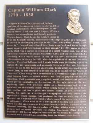
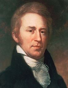
Captain William Clark epitomized the best qualities of the American citizen-soldier and their seminal contributions to the development of the United States. Clark was born 1 August, 1770 to a modest, but accomplished and fiercely patriotic Virginia family. Clark began his military career at 19 in the Kentucky militia. Transferred to the Regular Army as a lieutenant, he served in challenging postings in the "Old North-West" where, Clark wrote, he "...learned how to build forts, draw maps, lead pack trains through enemy country, and fight Indians on their ground." By 1795, rising on sheer merit, Clark was a captain in command of a small frontier post. One of his subordinate officers was Ensign Meriwether Lewis and the two established a friendship which would result in one of the most successful military collaborations in history. In 1803, after the acquisition of the vast Louisiana Territory, President Jefferson and Captain Lewis were developing a plan to explore the key geographic and economic features of this new American frontier. To aid in this daunting undertaking, Lewis avidly recruited his old friend Clark, by then returned to private life, as co-leader for the "Corps of Discovery." Clark was given a commission as a "Volunteer" Captain and set about helping Lewis to recruit soldiers and finalize preparations for the expedition. Clark possessed many physical, moral, and intellectual qualities which proved invaluable to the success of this epic mission. He was physically robust with practical skills as a frontiersman and was an optimistic and charismatic leader. While lacking formal education, he had a keen intellect and was a quick and careful student of new information. Finally, his skills as a self-taught cartographer not only ensured the expedition's secure passage, but produced the first accurate map of the Missouri and Columbia river systems which opened the continental interior to settlement. Clark went on to a distinguished military and civil career which included appointment as Brigadier General of Militia, Governor of the Missouri Territory, and Superintendent of Indian Affairs where he was a tireless and respected advocate for Native Americans. Clark died in September 1838 having helped to transform the wilderness he courageously explored into a United States stretching from the Atlantic to the Pacific.
Erected by United States Army.
Topics and series. This historical marker is listed in these topic lists: Exploration • Forts and Castles. In addition, it is included in the Former U.S. Presidents: #03 Thomas Jefferson, and the Lewis & Clark Expedition series lists. A significant historical month for this entry is September 1838.
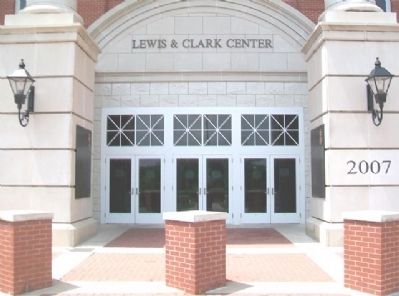
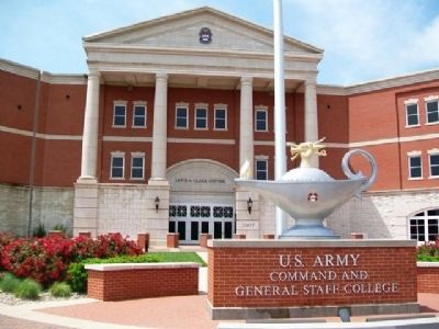
Location. 39° 20.645′ N, 94° 54.928′ W. Marker is in Fort Leavenworth, Kansas, in Leavenworth County. Marker is on Stimson Avenue, on the right when traveling west. Marker is at the entrance to the Lewis and Clark Center. Touch for map. Marker is in this post office area: Fort Leavenworth KS 66027, United States of America. Touch for directions.
Other nearby markers. At least 8 other markers are within walking distance of this marker. Captain Meriwether Lewis (a few steps from this marker); General Creighton W. Abrams (within shouting distance of this marker); The United States Army Command and General Staff College (about 300 feet away, measured in a direct line); The Buffalo Soldier Monument (approx. ¼ mile away); General Roscoe Robinson Jr. (approx. ¼ mile away); BG Benjamin H. Grierson (approx. ¼ mile away); 555th Parachute Infantry Company (approx. ¼ mile away); General Colin L. Powell (approx. ¼ mile away). Touch for a list and map of all markers in Fort Leavenworth.
More about this marker. Public access to the post is possible with proper identification, subject to U.S. Army regulations.
Related markers. Click here for a list of markers that are related to this marker.
Also see . . .
1. William Clark. Wikipedia entry (Submitted on December 22, 2023, by Larry Gertner of New York, New York.)
2. Lewis and Clark National Historic Trail. National Park Service website entry (Submitted on July 13, 2013, by William Fischer, Jr. of Scranton, Pennsylvania.)
Credits. This page was last revised on December 22, 2023. It was originally submitted on July 13, 2013, by William Fischer, Jr. of Scranton, Pennsylvania. This page has been viewed 649 times since then and 24 times this year. Photos: 1. submitted on July 13, 2013, by William Fischer, Jr. of Scranton, Pennsylvania. 2. submitted on December 22, 2023, by Larry Gertner of New York, New York. 3, 4. submitted on July 12, 2013, by William Fischer, Jr. of Scranton, Pennsylvania.


