Raphine in Rockbridge County, Virginia — The American South (Mid-Atlantic)
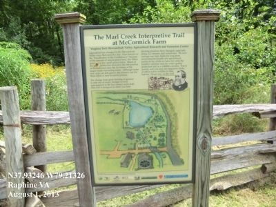
The Marl Creek Interpretive Trail
At McCormick Farm
The change from grain farming to pasture is only one of many changes in land management in the last century and a half. This trail is designed to show you how farming practices have changed, especially along our streams and waterways. We now manage our farm fields for long-term environmental health an agricultural productivity, while we have set aside the sensitive riparian area for water quality protection and as a wildlife corridor. Travel quietly, and you may see migratory birds, or other native wildlife in their habitat. Please stay on the trail.
Topics. This historical marker is listed in this topic list: Agriculture.
Location. 37° 55.948′ N, 79° 12.796′ W. Marker is in Raphine, Virginia, in Rockbridge County. Marker is on McCormick's Farm Circle. Touch for map. Marker is at or near this postal address: 128 McCormick's Farm Circle, Raphine VA 24472, United States of America. Touch for directions.
Other nearby markers. At least 8 other markers are within 6 miles of this marker, measured as the crow flies. Walnut Grove (a few steps from this marker); Cyrus H. McCormick (within shouting distance of this marker); Rockbridge County / Augusta County (approx. 0.7 miles away); New Providence Church (approx. ¾ mile away); Virginia Inventors (approx. ¾ mile away); Old Providence Church (approx. 1.6 miles away); New Providence Presbyterian Church (approx. 5 miles away); Brownsburg (approx. 5.8 miles away). Touch for a list and map of all markers in Raphine.
Credits. This page was last revised on June 16, 2016. It was originally submitted on August 2, 2013, by Don Morfe of Baltimore, Maryland. This page has been viewed 670 times since then and 19 times this year. Photos: 1, 2. submitted on August 2, 2013, by Don Morfe of Baltimore, Maryland. • Bill Pfingsten was the editor who published this page.

