Sullivans Island in Charleston County, South Carolina — The American South (South Atlantic)
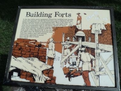
Building Forts
In the days before power equipment existed fort building took muscle, sweat and ingenuity, and the big brick forts such as Moultrie III and Sumter required masons of unsurpassed skill. Most of the labor on the first two forts built of sand, palmetto logs, and light brickwork was accomplished with ax and shovel, mainly by slaves from nearby plantations. Master masons, both black and white, slave and free, worked to build the massive brick walls of Fort Moultrie III. It was not until the 1890’s when the Endicott batteries were built that modern steel and concrete construction appeared in coastal forts and the days of hand labor ended.
Erected by National Park Service.
Topics. This historical marker is listed in this topic list: Forts and Castles.
Location. 32° 45.577′ N, 79° 51.514′ W. Marker is on Sullivans Island, South Carolina, in Charleston County. Marker can be reached from Middle Street, on the left when traveling west. Touch for map. Marker is in this post office area: Sullivans Island SC 29482, United States of America. Touch for directions.
Other nearby markers. At least 8 other markers are within walking distance of this marker. Enlisted Men's Barracks (within shouting distance of this marker); Harbor Defense 1809-1860 (within shouting distance of this marker); Powder Magazine (within shouting distance of this marker); Traverse c.1820 (within shouting distance of this marker); Northwest Bastionet (within shouting distance of this marker); Defending Charleston 1861-1865 (within shouting distance of this marker); Move a 50,000 pound Rodman Gun (within shouting distance of this marker); Oceola / Patapsco Dead (within shouting distance of this marker). Touch for a list and map of all markers in Sullivans Island.
More about this marker. The background of the marker contains a picture of men building a masonry fort.
Also see . . . Fort Moultrie. National Park Service website. (Submitted on August 6, 2013, by Bill Coughlin of Woodland Park, New Jersey.)
Credits. This page was last revised on June 16, 2016. It was originally submitted on August 6, 2013, by Bill Coughlin of Woodland Park, New Jersey. This page has been viewed 481 times since then and 17 times this year. Photos: 1, 2, 3, 4. submitted on August 6, 2013, by Bill Coughlin of Woodland Park, New Jersey.


