Marker Logo
THE HISTORICAL
MARKER DATABASE
“Bite-Size Bits of Local, National, and Global History”
Olde Uptown in Harrisburg in Dauphin County, Pennsylvania — The American Northeast (Mid-Atlantic)
 

Simon Cameron School
 
 
Simon Cameron School Marker image. Click for full size.
Photographed by William Pfingsten, March 30, 2008
1. Simon Cameron School Marker
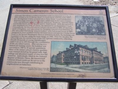
Inscription. Although Harrisburg's northern boundary when incorporated as a city in 1860 reached as far as Maclay Street, it would not be until the early 1890's that development widely occurred above Reily Street. Local homebuilder Benjamin Engle launched the first major subdivision in this area, a Queen Anne and Italianate-styled community known as "Engleton," between Reily and Kelker Streets and N. Second and N. Third Streets. With this sprawling new neighborhood came of course, the demand for an elementary school. Consequently, the Simon Cameron School was erected in 1896, on land just north of Engleton, and was named for President Lincoln's first Secretary of War and noted Harrisburg "empire-builder" who had passed away in 1889. Designed by local architect Charles Howard Lloyd and partner Charles James Foose in the Second Renaissance Revival architectural style, the building was expanded to the rear using the same design in 1904. Over the decades, the school became the central focus of the Old Uptown community, educating literally thousands of young Harrisburgers until it closed in 1972 through the consolidation of the city school
Paid Advertisement
Click or scan to see
this page online
system. After serving as a federal job-training center, the building was converted in 1987 to 35 upscale apartments. many of the former school's historic qualities were retained including the grand halls, high ceilings and abundant supply of nine-foot tall windows. individually listed in the National Register of Historic Places, the transformed Cameron School continues its service to the community, now through contributing to neighborhood revitalization.
Top Photo
Class of Miss Sue Bretten is captured at the School's northern Green street entrance on January 14, 1898.
Bottom Photo
1904 postcard view of the Simon Cameron School after completion of the building's rear wing.

 
Erected by The Harrisburg History Project Commissioned by Mayor Stephen R. Reed.
 
Topics and series. This historical marker is listed in this topic list: Education. In addition, it is included in the Former U.S. Presidents: #16 Abraham Lincoln, and the Pennsylvania, The Harrisburg History Project series lists. A significant historical month for this entry is January 1850.
 
Location. 40° 16.553′ N, 76° 53.71′ W. Marker is in Harrisburg, Pennsylvania, in Dauphin County.
Simon Cameron Elementary School image. Click for full size.
Photographed by William Pfingsten, March 30, 2008
2. Simon Cameron Elementary School
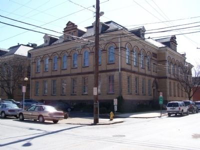
Now an apartment building.

It is in Olde Uptown. It is at the intersection of Green Street and Muench Street, on the right when traveling south on Green Street. Touch for map. Marker is at or near this postal address: 1836 Green St, Harrisburg PA 17102, United States of America. Touch for directions.

Regionally, this marker is in South-Central Pennsylvania, specifically in Pennsylvania Dutch Country, and in the Susquehanna Valley. It is also in the American Northeast and in the Mid-Atlantic. Globally, it is in North America, the Western Hemisphere, the Western World, and the Anglosphere. Historically, it finds itself in what was once the Haudenosaunee (Iroquois) Confederacy and also one of the original Thirteen Colonies.

Other nearby markers. At least 8 other markers are within walking distance of this marker: Tracy Mansion (approx. 0.2 miles away); Reily Hose Company No. 10 (approx. 0.2 miles away); Cottage Ridge (approx. 0.2 miles away); Governor's Residence (approx. 0.2 miles away); Pennsylvania Governor's Residence (approx. Ό mile away); a different marker also named Governor's Residence (approx. Ό mile away); Women's World War I Memorial (approx.
Paid Advertisement
0.3 miles away); Charles Y. Petty Sr. (approx. 0.4 miles away). Touch for a list and map of all markers in Harrisburg.
 
 
Credits. This page was last revised on December 5, 2019. It was originally submitted on March 31, 2008, by Bill Pfingsten of Bel Air, Maryland. This page has been viewed 2,981 times since then and 78 times this year. Photos:   1, 2. submitted on March 31, 2008, by Bill Pfingsten of Bel Air, Maryland.

m=6796

CeraNet Cloud Computing sponsors the Historical Marker Database.
This website earns income from purchases you make after using our links to Amazon.com. We appreciate your support.
Paid Advertisement
Jul. 7, 2026