
Near Magdalena in Socorro County, New Mexico — The American Mountains (Southwest)
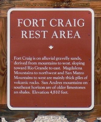
Fort Craig Rest Area
Photographed by PaulwC3, July 21, 2013
1. Fort Craig Rest Area Marker
Erected by New Mexico Historic Preservation Division.
Topics and series. This historical marker is listed in this topic list: Natural Features. In addition, it is included in the El Camino Real de Tierra Adentro series list.
Location. 33° 37.352′ N, 107° 8.324′ W. Marker is near Magdalena, New Mexico, in Socorro County. It can be reached from CanAm Highway (Interstate 25 at milepost 113), 1.2 miles south of State Road 107, on the right when traveling south. The marker is southbound rest area on Interstate 25 at Mile 113. Touch for map. Marker is in this post office area: Magdalena NM 87825, United States of America. Touch for directions.

Regionally, this marker is in Southwest New Mexico and in the Rio Grande Valley. It is also in the American
this page online
Other nearby markers. At least 8 other markers are within 5 miles of this marker, measured as the crow flies: Paraje de Fra Cristobal (here, next to this marker); Espejo's Expedition (here, next to this marker); Paraje De Fra Cristobal (about 600 feet away, measured in a direct line); Women of the Camino Real (about 600 feet away); Fort Craig (about 600 feet away); Vásquez de Coronado’s Route (about 600 feet away); Time & Perspective (approx. 4½ miles away); Guarding the Trail (approx. 4½ miles away). Touch for a list and map of all markers in Magdalena.
Photographed by PaulwC3, July 21, 2013
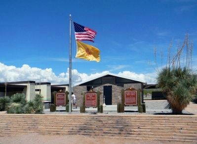
2. Wide view of the Fort Craig Rest Area Marker
Of the three markers, the Fort Craig Rest Area marker is the on the right hand side.
Credits. This page was last revised on October 23, 2021. It was originally submitted on August 24, 2013, by PaulwC3 of Northern, Virginia. This page has been viewed 1,348 times since then and 64 times this year. Photos: 1, 2. submitted on August 24, 2013, by PaulwC3 of Northern, Virginia.
