Clarksville in Montgomery County, Tennessee — The American South (East South Central)
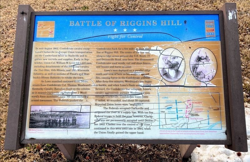
Battle of Riggins Hill
Fight for Control
As Lowe marched eastward from Dover, scouts from Confederate Col. Thomas Woodward’s 2nd Kentucky Cavalry fired on the column as it neared Clarksville on September 7. Woodward’s force numbered some 700 men including armed townsmen. The Federals pushed the Confederates back for a few miles to their main line at Riggins’ Hill. The center of the line was along a ridge across present-day U.S. Route 79 and Dotsonville Road, near here. The dismounted Confederates used woods, rail and stone fences, and houses and barns as cover.
Lowe’s men deployed on a parallel ridge south and west of here as his artillery opened fire, causing havoc in the Confederate position. After forty-five minutes, Woodward’s line began to buckle, and when Lowe’s flank units pushed forward, the Confederate line collapsed. Lowe’s cavalry aggressively pursued Woodward’s men through Clarksville. Confederate losses were 17 killed, 40 wounded, and about 50 captured. Reported Union losses were “negligible.”
The Federals occupied Clarksville and reopened the river as a supply line. With too few Federal troops to hold the area, however, Clarksville was not permanently occupied until December 1862. Clashes over the control of the river continued in this area until late in 1864, when the Union finally gained the upper hand.
(captions)
5th Iowa Cavalry - Courtesy Customs House Museum and Cultural Center, Clarksville, Tennessee
Col. William Lowe Courtesy Rootsweb.ancestory.com
Col. Thomas Woodward Courtesy Kentucky Library, Western Kentucky University
(map) Ahead of you is the road on which a Union force from Fort Donelson approached Clarksville bent on recapturing the town.
Erected by Tennessee Civil War Trails.
Topics and series. This historical marker is listed in this topic list: War, US Civil. In addition, it is included in the Tennessee Civil War Trails series list. A significant historical year for this entry is 1862.
Location. 36° 33.206′ N, 87° 25.458′ W. Marker is in Clarksville, Tennessee, in Montgomery County. Marker is at the intersection of Magnolia Drive and Dover Road (U.S. 79), on the left when traveling north on
Magnolia Drive. Touch for map. Marker is in this post office area: Clarksville TN 37042, United States of America. Touch for directions.
Other nearby markers. At least 8 other markers are within 3 miles of this marker, measured as the crow flies. Montgomery County Soldiers And Sailors World War I Monument (approx. 1.9 miles away); Trice's Landing (approx. 2½ miles away); Valentine Sevier, Memorial (approx. 2.9 miles away); Valentine Sevier Station (approx. 2.9 miles away); Sevier Station (approx. 2.9 miles away); Forts Versus Ironclads (approx. 2.9 miles away); Building Fort Sevier (Defiance) (approx. 2.9 miles away); Fort Defiance (approx. 3 miles away). Touch for a list and map of all markers in Clarksville.
Credits. This page was last revised on May 10, 2021. It was originally submitted on September 13, 2013, by Don Morfe of Baltimore, Maryland. This page has been viewed 1,706 times since then and 122 times this year. Photos: 1. submitted on September 13, 2013, by Don Morfe of Baltimore, Maryland. 2. submitted on May 10, 2021, by Shane Oliver of Richmond, Virginia. 3. submitted on September 13, 2013, by Don Morfe of Baltimore, Maryland. • Bernard Fisher was the editor who published this page.


