Georgetown in Northwest Washington in Washington, District of Columbia — The American Northeast (Mid-Atlantic)
Parrott Ropewalk
Photographed by Allen C. Browne, September 14, 2013
1. Parrott Ropewalk Marker
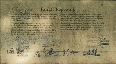
The ropewalk receives its name from the long path used for the laying out of individual yarns of rope prior to twisting them together.
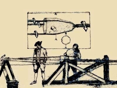
Rope making was accomplished by first combing hemp and attaching it to a clockwise revolving hook spinning it into yarns.
Several yarns were then attached to separate hooks and twisted together counterclockwise to form strands. These three strands were twisted together clockwise again making rope.
Because of the constant change in direction, the rope would not unravel. If a larger rope was needed, three ropes could be twisted together to form anchor cable.
Topics. This historical marker is listed in this topic list: Industry & Commerce.
Location. 38° 54.781′ N, 77° 3.647′ W. Marker is in Northwest Washington in Washington, District of Columbia. It is in Georgetown. It can be reached from the intersection of R Street Northwest and Avon Place Northwest, on the left when traveling
this page online

Regionally, this marker is in the Washington Metropolitan Area. It is also in the American Northeast, in the Upper South, in the Mid-Atlantic, in the Tidewater, and in the Chesapeake Bay Region. Globally, it is in North America, the Western Hemisphere, the Western World, and the Anglosphere.
Other nearby markers. At least 8 other markers are within walking distance of this marker: Montrose Park (about 400 feet away, measured in a direct line); In Memory of Lucia Eames Blount (about 600 feet away); Stephen Osusky (about 700 feet away); Cold Frames (about 700 feet away); East Lawn (about 700 feet away); Watching the Flames (about 700 feet away); Dumbarton Oaks (about 700 feet away); South Lawn (approx. 0.2 miles away). Touch for a list and map of all markers in Northwest Washington.
Additional commentary.
1. Elderslie, Parrott's Woods and the Ropewalk
Industrialist Richard Parrott put together a large property here
Photographed by Allen C. Browne, September 14, 2013
2. Parrott Ropewalk Marker
— Submitted September 16, 2013, by Allen C. Browne of Silver Spring, Maryland.
Photographed by Allen C. Browne, September 15, 2013
3. Ropewalk
The wooden "top" keeps the strands separate until they are twisted together.
Close-up of image on marker
Photographed by Allen C. Browne, September 14, 2013
4. Some common types of rope
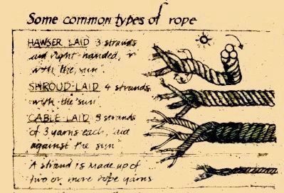
Hauser Laid 3 strands laid right-handed or "with the sun".
Shroud Laid 4 strands with the sun.
Cable Laid 3 strands of 3 yarns each laid against the sun.
==============
A Strand is made of two or more rope yarns.
Close-up of image on marker
Shroud Laid 4 strands with the sun.
Cable Laid 3 strands of 3 yarns each laid against the sun.
Photographed by Allen C. Browne, September 14, 2013
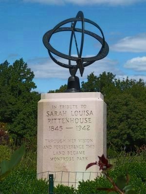
5. The Armillary Sphere at Montrose Park
Sarah Louisa
Rittenhouse
1845 - 1942
This memorial erected by the Georgetown Garden Club in 1956 marks the location of the old mansion house.
Photographed by Allen C. Browne, September 14, 2013
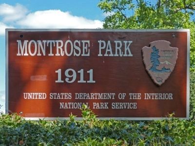
6. Montrose Park
1911
1911
United States Department of the Interior
National Park Service.
National Park Service.
Credits. This page was last revised on January 30, 2023. It was originally submitted on September 16, 2013, by Allen C. Browne of Silver Spring, Maryland. This page has been viewed 1,502 times since then and 42 times this year. Photos: 1, 2, 3, 4, 5, 6. submitted on September 16, 2013, by Allen C. Browne of Silver Spring, Maryland. • Bill Pfingsten was the editor who published this page.
