Near Angels Camp in Calaveras County, California — The American West (Pacific Coastal)
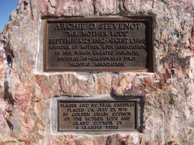
Archie D. Stevenot
“Mr. Mother Lode”
Founder of Mother Lode Association in 1919, which created colorful Highway 49 – California’s first highway association.
Plaque and 100 year capsules placed on July 23, 1976 by Golden Chain Council of the Mother Lode and Grand Council of E Clampus Vitus
Erected 1976 by Golden Chain Council of the Mother Lode and Grand Council of E Clampus Vitus.
Topics and series. This historical marker is listed in this topic list: Roads & Vehicles. In addition, it is included in the E Clampus Vitus series list. A significant historical date for this entry is July 23, 1976.
Location. 38° 0.545′ N, 120° 30.285′ W. Marker is near Angels Camp, California, in Calaveras County. Marker is on State Highway 49, on the left when traveling south. Marker is 5.6 miles south of Angels Camp and 0.3 miles north of New Melones Reservoir. Touch for map. Marker is in this post office area: Angels Camp CA 95222, United States of America. Touch for directions.
Other nearby markers. At least 8 other markers are within 3 miles of this marker, measured as the crow flies. Robinson's Ferry (here, next to this marker); The Story Under the Lake (approx. one mile away); Archie Stevenot (approx. 1.3 miles away); Carson Hill (approx. 1.3 miles away); James H. Carson (approx. 1.3 miles away); Mark Twain Cabin (approx. 1.7 miles away); a different marker also named Mark Twain Cabin (approx. 1.7 miles away); a different marker also named Mark Twain Cabin (approx. 2.3 miles away). Touch for a list and map of all markers in Angels Camp.
Additional commentary.
1. The Archie D. Stevenot Memorial Bridge
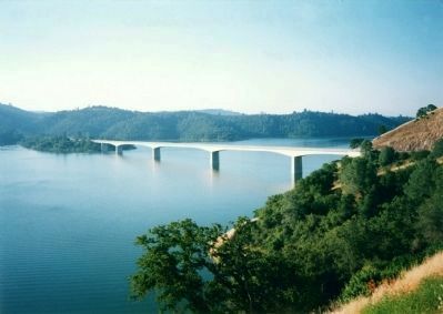
Bridge 32-040 over the Stanislaus River in Tuolumne and Calaveras counties is named the "Archie D. Stevenot Memorial Bridge". It was constructed in 1976, and was named by Senate Resolution 338, Page 4758, in 1988. Archie Stevenot (d. 1968), miner, cowboy, rancher, postmaster, and ox team swamper, helped found the California State Chamber of Commerce and was officially named "Mr. Mother Lode" by the California legislature. He was also the founder of the "Mother Lode Association" in 1919, which was the first highway association and promoted the assignment of the number "49" to Route 49.
— Submitted April 4, 2008, by Kevin W. of Stafford, Virginia.
2. E Clampus Vitae Time Capsule
A time capsule was buried
on July 23, 1976 overlooking the Archie D. Stevenot Memorial Bridge, State Highway 49, over the Stanislaus River between Tuolumne and Calaveras County, on the Calaveras side. It contains material (proclamations, announcements, etc.) from each E Clampus Vitae Chapter then in existence. The niche is 2' x 2' x 4', concrete-encased. The copper time capsule was prepared by Hal Goodyear SNGH 1971-73) from material "that will withstand time and weather" for one hundred years.
— Submitted April 4, 2008, by Kevin W. of Stafford, Virginia.
Credits. This page was last revised on June 16, 2016. It was originally submitted on April 4, 2008, by Richard Wisehart of Sonora, California. This page has been viewed 2,488 times since then and 56 times this year. Photos: 1, 2, 3. submitted on April 2, 2008, by Richard Wisehart of Sonora, California. • Kevin W. was the editor who published this page.


