Beaufort in Beaufort County, South Carolina — The American South (South Atlantic)
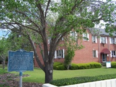
Mather School

Photographed by Mike Stroud, April 2008
1. Mather School Marker
Erected 1982 by Mather School Alumnae Association. (Marker Number 7-16.)
Topics. This historical marker is listed in these topic lists: African Americans • Education. A significant historical year for this entry is 1882.
Location. 32° 25.203′ N, 80° 41.305′ W. Marker is in Beaufort, South Carolina, in Beaufort County. It is on Ribaut Road (State Highway 281) 0 miles south of Reynolds Street, on the right when traveling south. Touch for map. Marker is in this post office area: Beaufort SC 29902, United States of America. Touch for directions.

Regionally, this marker is in the Lowcountry and on the Sea Islands. It is also in the American South, specifically in the Deep South, and on the Eastern Seaboard. Globally, it is in the North Atlantic Region,
this page online
Other nearby markers. At least 8 other markers are within 2 miles of this marker, measured as the crow flies: Beaufort Historic District (approx. 1.1 miles away); Thomas Heyward, Jr. (approx. 1.1 miles away); Beaufort County, South Carolina (approx. 1.1 miles away); a different marker also named Beaufort County, South Carolina (approx. 1.1 miles away); Beaufort County South Carolina (approx. 1.2 miles away); Maxcy-Rhett House / "Secession House" (approx. 1.2 miles away); First Presbyterian Church (approx. 1.2 miles away); Freedmen's Bank Building (approx. 1.2 miles away). Touch for a list and map of all markers in Beaufort.
Photographed by Mike Stroud, 2008
2. Now site of The Techincal College Of The Lowcountry
Credits. This page was last revised on October 18, 2020. It was originally submitted on April 7, 2008, by Mike Stroud of Bluffton, South Carolina. This page has been viewed 4,501 times since then and 45 times this year. Photos: 1, 2. submitted on April 7, 2008, by Mike Stroud of Bluffton, South Carolina. • Christopher Busta-Peck was the editor who published this page.
