Upper Fairmount in Somerset County, Maryland — The American Northeast (Mid-Atlantic)
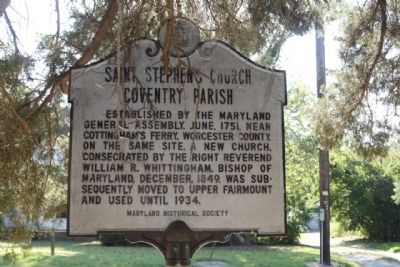
Saint Stephen's Church
Coventry Parish
Photographed by Mike Stroud, October 5, 2013
1. Saint Stephen's Church Coventry Parish Marker
Erected 1969 by Maryland Historical Society.
Topics and series. This historical marker is listed in this topic list: Religion & Religious Structures. In addition, it is included in the Maryland Historical Trust series list. A significant historical year for this entry is 1751.
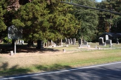
Location. 38° 6.343′ N, 75° 47.597′ W. Marker is in Upper Fairmount, Maryland, in Somerset County. It is on Fairmount Road (Maryland Route 361), on the right when traveling west. Located about 900 feet west of Upper Hill Road. Touch for map. Marker is in this post office area: Upper Fairmount MD 21867, United States of America. Touch for directions.

Regionally, this marker is on the Eastern Shore. It is also in the American Mid-Atlantic, on the Delmarva Peninsula, in the Tidewater, in the Chesapeake Bay Region, and on the Eastern Seaboard. Globally, it
this page online
Other nearby markers. At least 8 other markers are within 8 miles of this marker, measured as the crow flies: Gen. Arnold Elzey C.S.A. (approx. 4.6 miles away); "Bloomsbury" (approx. 5.6 miles away); Ye Old St. Peters Methodist Church (approx. 6.3 miles away); Old Ailsey's Light (approx. 6.9 miles away); Fields and Pastures (approx. 7 miles away); Daugherty Creek Canal (approx. 7.1 miles away); Loblolly Pine (approx. 7.2 miles away); Crisfield: The City Built on Oysters (approx. 7.2 miles away).
Another marker is no longer nearby. First Site of Washington Academy (was approx. 4.8 miles away but has been confirmed missing).
Photographed by Mike Stroud, October 5, 2013
2. Saint Stephen's Church Coventry Parish Marker (Left) seen along Fairmount Road
Credits. This page was last revised on December 29, 2024. It was originally submitted on October 17, 2013, by Mike Stroud of Bluffton, South Carolina. This page has been viewed 633 times since then and 34 times this year. Photos: 1, 2. submitted on October 18, 2013, by Mike Stroud of Bluffton, South Carolina.
