Near Sharpsburg in Washington County, Maryland — The American Northeast (Mid-Atlantic)
Battery A, 2d U.S. Artillery

Photographed By Craig Swain, April 6, 2008
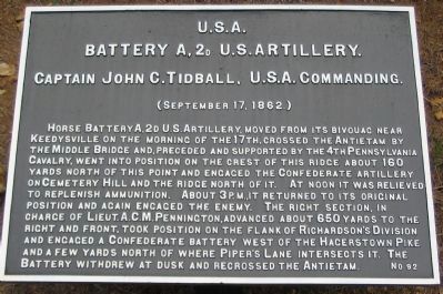
1. Battery A, 2nd U.S. Artillery Tablet
The Wildcat Battery: Company A, 2nd U.S. Artillery 1861 – 1865
Website homepage
Click for more information.
Website homepage
Click for more information.
Battery A, 2d U.S. Artillery.
Captain John C. Tidball, U.S.A. Commanding.
(September 17, 1862.)
Horse Battery A, 2d U.S. Artillery, moved from its bivouac near Keedysville on the morning of the 17th, crossed the Antietam by the Middle Bridge and, preceded and supported by the 4th Pennsylvania Cavalry, went into position on the crest of this ridge about 160 yards north of this point and engaged the Confederate artillery on Cemetery Hill and the ridge north of it. At noon it was relieved to replenish ammunition. About 3 p.m., it returned to its original position and again engaged the enemy. The right section, in charge of Lieut. A.C.M. Pennington, advanced about 650 yards to the right and front, took position on the flank of Richardson's Division and engaged a Confederate battery west of the Hagerstown Pike and a few yards north of where Piper's Lane intersects it. The Battery withdrew at dusk and recrossed the Antietam.
Erected by Antietam Battlefield Board. (Marker Number 92.)
Topics and series. This historical marker is listed in this topic list: War, US Civil. In addition, it is included in the Antietam Campaign War Department Markers series list. A significant historical year for this entry is 1862.
Location. 39° 27.804′ N, 77° 43.895′ W. Marker is near Sharpsburg, Maryland, in Washington County. Marker is on Boonsboro / Shepherdstown Pike (State Highway 34), on the right when traveling west. Located in a cluster of Federal artillery tablets. Touch for map. Marker is in this post office area: Sharpsburg MD 21782, United States of America. Touch for directions.
Other nearby markers. At least 8 other markers are within walking distance of this marker. Battery E, 1st U.S. Artillery (a few steps from this marker); Batteries C and G, 3d U.S. Artillery (a few steps from this marker); Batteries B and L, 2d U.S. Artillery (a few steps from this marker); Battery M, 2d U.S. Artillery (a few steps from this marker); Battery K, 5th U.S. Artillery (a few steps from this marker); Horse Batteries and Reserve Artillery (a few steps from this marker); V Corps, 2nd Division, 1st Brigade (about 300 feet away, measured in a direct line); Twelfth United States Infantry (about 400 feet away). Touch for a list and map of all markers in Sharpsburg.
Regarding Battery A, 2d U.S. Artillery. Battery A had a distinguished service record during the Civil War. It defended the capital during Lincoln's inauguration. At the First Manassas, the battery formed the rear guard that saved the Federal army from further destruction. Later battles and campaigns included the Seven Days Battles, Antietam, Gettysburg, the Overland Campaign, and Five Forks. Some of the last

Photographed By Craig Swain, April 6, 2008
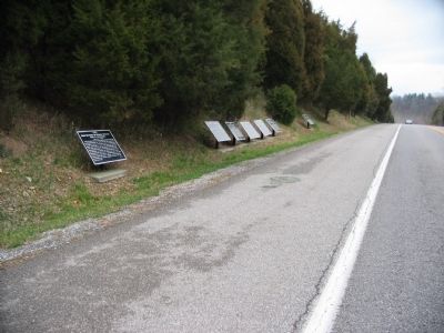
2. Federal Artillery Tablet Cluster on Boonsboro Pike
Closest to the camera to furthest: Horse Batteries and Reserve Artillery (Number 30), Battery K, 5th U.S. (Number 97), Battery M, 2d U.S. (Number 93), Batteries B and L, 2d U.S. (Number 94), Batteries C and G, 3d U.S. (Number 95), Battery E, 1st U.S. (Number 96), and Battery A, 2d U.S. (Number 92).
Also see . . .
1. Antietam Battlefield. National Park Service site. (Submitted on April 11, 2008, by Craig Swain of Leesburg, Virginia.)
2. Tidball's Battery of the Horse Artillery. Tidball's Battery was armed with between four and six 3-inch Ordnance Rifled Cannon. (Submitted on April 11, 2008, by Craig Swain of Leesburg, Virginia.)
Additional commentary.
1. Citations from the Captions
The citations for the captions were taken from Artillery Hell: The Employment of Artillery at Antietam, by Curt Johnson and Richard C. Anderson, Jr. The after action report of Captain Tidball is reprinted on pages 111-113. It was for some reason omitted from the Official Records but preserved in the papers of General Henry Hunt. Tidball further reported the loss of one man killed and three wounded. The battery expended 1200 rounds during the day. Closing his report, Tidball wrote, ...I beg leave to add that the use of horse batteries being a new thing in our service, does not appear to be very well comprehended by those [indistinct] whose command they most frequently [indistinct]....If, when the crisis arrived, and batteries were so much required on the left, the

Photographed By Craig Swain, April 6, 2008
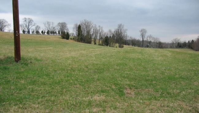
3. Tidball's Guns Going in to Action
In his report of the battle, Tidball would write, In front of the enemy's Sharpshooters were posted and there being no infantry at hand to drive them back, I opened fire upon them with Canister, and gradually worked my guns by hand up a steep ploughed field to the crest of the hill.... Based on the tablet's description and the Antietam Battlefield Board maps, it was the slopes here, just to the north of the Pike, that Tidball's men advanced their guns by hand.
— Submitted April 11, 2008, by Craig Swain of Leesburg, Virginia.

Photographed By Craig Swain, April 6, 2008
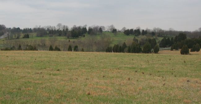
4. Tidball's Field of Fire
Tidball's report continued that he placed his guns in a commanding position not only for the enemy directly in front, but for an enfilading fire in front of Sumner's Corps on the right and that of Burnside on the left of me. This view, from atop the rise where Tidball's guns were placed, the Boonsboro Pike is on the far left. The high ground in the center is the major elevation south of the Piper Farm. At the time of the battle, this was the center of the Confederate defenses. Just to the right of that high ground is a ravine opening behind the Sunken Road.
Credits. This page was last revised on May 13, 2022. It was originally submitted on April 11, 2008, by Craig Swain of Leesburg, Virginia. This page has been viewed 1,112 times since then and 21 times this year. Photos: 1, 2, 3, 4. submitted on April 11, 2008, by Craig Swain of Leesburg, Virginia.