Henderson Harbor in Jefferson County, New York — The American Northeast (Mid-Atlantic)
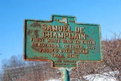
Samuel de Champlain
Passed over Indian trail here.
Erected 1932 by New York State Education Department.
Topics. This historical marker is listed in these topic lists: Exploration • Native Americans. A significant historical date for this entry is October 28, 1615.
Location. 43° 50.892′ N, 76° 12.73′ W. Marker is in Henderson Harbor, New York, in Jefferson County. Marker is on Military Road (New York State Route 178) 0.7 miles west of Harbor Road (New York State Route 123), on the right when traveling west. Touch for map. Marker is in this post office area: Henderson NY 13650, United States of America. Touch for directions.
Other nearby markers. At least 8 other markers are within 8 miles of this marker, measured as the crow flies. 1820 Oliver Bates Home (approx. 1.8 miles away); Camp de L'Observation (approx. 1.8 miles away); Carrying Cable Route (approx. 5 miles away); New Brunswick's 104th Regiment of Foot (approx. 7.4 miles away); Horse Island (approx. 7.4 miles away); a different marker also named Carrying Cable Route (approx. 7˝ miles away); a different marker also named Carrying Cable Route (approx. 7.6 miles away); The Landing Area (approx. 7.9 miles away).
Also see . . .
1. Samuel de Champlain biography. Biography.com (Submitted on November 28, 2013, by Mike Wintermantel of Pittsburgh, Pennsylvania.)
2. Samuel de Champlain at FindAGrave.com. (Submitted on November 28, 2013, by Mike Wintermantel of Pittsburgh, Pennsylvania.)
Credits. This page was last revised on June 16, 2016. It was originally submitted on November 28, 2013, by Mike Wintermantel of Pittsburgh, Pennsylvania. This page has been viewed 592 times since then and 20 times this year. Photos: 1, 2. submitted on November 28, 2013, by Mike Wintermantel of Pittsburgh, Pennsylvania.

