Near Baldwyn in Prentiss County, Mississippi — The American South (East South Central)
Terrain and Landscape
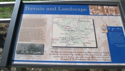
During the 1860s some of the land was used to grow cotton and corn, but much of the area remained wooded with dense underbrush. The battlefield of Brice's Crossroads, therefore, was as much forest as field, which greatly affected how soldiers could fight. Cavalry troops had to leave their horses in the rear and venture into the forest on foot. Soldiers might be just a few yards away from the enemy line and yet not able to see them through the underbrush.
"The day was extremely hot and sultry, the country was largely woodland, the roads very muddy, and the rapid march, under a scorching sun, had a very exhausting effect upon the men." —Sergeant C.F. Macdonald, 9th Minnesota Infantry
(Sidebar)
The Agnew Diaries
"Tippah Co. Life: When I first came here I was bewildered. Every way I looked I saw woods - no clearing. I saw for the first time bored wells. Saw many things which appeared very strange at first but all have become common place to me now." —Samuel A. Agnew diary. December 15, 1852
Topics. This historical marker is listed in these topic lists: Churches & Religion • War, US Civil. A significant historical date for this entry is December 15, 2006.
Location. 34° 30.686′ N, 88° 43.913′ W. Marker is near Baldwyn, Mississippi, in Prentiss County. Marker can be reached from State Highway 370, 0.4 miles west of Bethany Road (State Highway 370), on the right when traveling west. The Tishomingo Overlook Road is a short park road that ends at a parking area and overlook (Auto Tour Stop 7). The marker is at the end loop and parking area. Touch for map. Marker is in this post office area: Baldwyn MS 38824, United States of America. Touch for directions.
Other nearby markers. At least 8 other markers are within walking distance of this marker. Artillery at Log Cabin Ridge (a few steps from this marker); Union Wagon Train (within shouting distance of this marker); Brice's Cross Roads (within shouting distance of this marker); General Barteau's Flank Movement (about 300 feet away, measured in a direct line); Tishomingo Creek Bridge (about 300 feet away); a different marker also named Brice's Cross Roads (about 400 feet away); Chief Tishomingo (about 400 feet away); a different marker also named Tishomingo Creek Bridge (about 500 feet away). Touch for a list and map of all markers in Baldwyn.
More about this marker.
A drawing (Upper Right Corner): "Skirmishing in the Woods" – Harper's Weekly
Map of the Roads and Adjacent Country between Stubbs' Plantation and Brice's Cross-Roads, Miss.," The Official Military Atlas of the Civil War, David Rumsey Collection
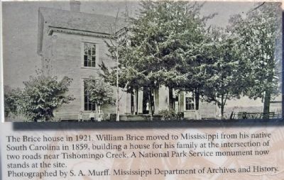
Photograph of the Brice House (See Photo #2).
Also see . . . Brices Cross Roads National Battlefield Site. National Park Service (Submitted on March 7, 2014.)
Credits. This page was last revised on June 16, 2016. It was originally submitted on March 7, 2014, by David Graff of Halifax, Nova Scotia. This page has been viewed 619 times since then and 20 times this year. Photos: 1, 2. submitted on March 7, 2014, by David Graff of Halifax, Nova Scotia. 3. submitted on December 3, 2015, by Brandon Fletcher of Chattanooga, Tennessee. • Bernard Fisher was the editor who published this page.


