Pensacola in Escambia County, Florida — The American South (South Atlantic)
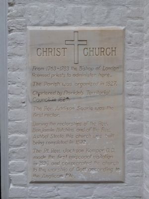
Christ Church
Photographed by Mark Hilton, March 11, 2014
1. Christ Church Marker
From 1763-1783 the Bishop of London licensed priests to administer here.
The Parish was organized in 1827.
Chartered by Florida's Territorial Council in 1829.
The Rev. Addison Searle was the first rector.
During the rectorships of the Rev. Benjamin Hutchins and of the Rev. Ashbel Steele this church was built being completed in 1832.
The Rt. Rev. Jackson Kemper D.D. made the first episcopal visitation in 1838 and consecrated the church to the worship of God according to the Anglican Rite.
Topics. This historical marker is listed in this topic list: Religion & Religious Structures. A significant historical year for this entry is 1827.
Location. 30° 24.551′ N, 87° 12.615′ W. Marker is in Pensacola, Florida, in Escambia County. It is at the intersection of South Adams Street and East Zarragossa Street, on the right when traveling south on South Adams Street. Tablet mounted near church entrance. Touch for map. Marker is at or near this postal address: 405 South Adams Street, Pensacola FL 32502, United States of America. Touch for directions.

Regionally, this marker is on the Florida Panhandle. It is also in
this page online
Other nearby markers. At least 8 other markers are within walking distance of this marker: A different marker also named Christ Church (here, next to this marker); Old Christ Church (within shouting distance of this marker); British Governor's House? (within shouting distance of this marker); Garrison's Kitchen (within shouting distance of this marker); British Well (within shouting distance of this marker); Firefighter Vista S. Lowe (about 300 feet away, measured in a direct line); Tivoli High House (about 300 feet away); Original Site of First Baptist Church (about 300 feet away). Touch for a list and map of all markers in Pensacola.
Also see . . . Historic Pensacola - Old Christ Church. University of West Florida Historic
Photographed by Mark Hilton, March 11, 2014
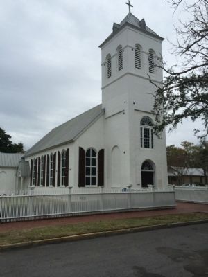
2. Old Christ Church
The marker can be seen to the right of the church's main entry.
Photographed by Mark Hilton, March 11, 2014
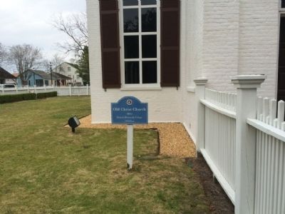
3. Christ Church Marker
1832
Historic Pensacola Village
Credits. This page was last revised on March 26, 2020. It was originally submitted on March 12, 2014, by Mark Hilton of Montgomery, Alabama. This page has been viewed 1,338 times since then and 33 times this year. Photos: 1, 2, 3. submitted on March 12, 2014, by Mark Hilton of Montgomery, Alabama. • Bernard Fisher was the editor who published this page.
