Sharpsburg in Washington County, Maryland — The American Northeast (Mid-Atlantic)
Longstreet's Command
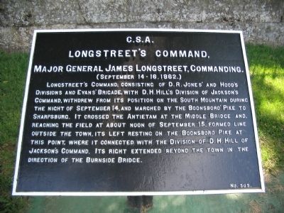
Longstreet's Command,
Major General James Longstreet, Commanding.
(September 14-16, 1862.)
Longstreet's command, consisting of D.R. Jones' and Hood's Divisions and Evans' Brigade, with D.H. Hill's Division of Jackson's Command, withdrew from its position on the South Mountain during the night of September 14, and marched by the Boonsboro' Pike to Sharpsburg. It crossed the Antietam at the Middle Bridge and, reaching the field at about noon of September 15, formed line outside the town, its left resting on the Boonsboro Pike at this point, where it connected with the Division of D.H. Hill of Jackson's Command. Its right extended beyond the town in the direction of Burnside Bridge.
Erected by Antietam Battlefield Board. (Marker Number 303.)
Topics and series. This historical marker is listed in this topic list: War, US Civil. In addition, it is included in the Antietam Campaign War Department Markers series list. A significant historical date for this entry is September 14, 1704.
Location. 39° 27.597′ N, 77° 44.545′ W. Marker is in Sharpsburg, Maryland, in Washington County. Marker is on Boonsboro Pike (State Highway 34), on the right when traveling east. Located in a Confederate tablet cluster just to the west of the National Cemetery entrance, stop eleven of the driving tour of Antietam Battlefield. Touch for map. Marker is in this post office area: Sharpsburg MD 21782, United States of America. Touch for directions.
Other nearby markers. At least 8 other markers are within walking distance of this marker. A different marker also named Longstreet's Command (here, next to this marker); Reserve Artillery, Longstreet's Command (here, next to this marker); Hood's Division, Longstreet's Command (here, next to this marker); a different marker also named Longstreet's Command (here, next to this marker); a different marker also named Longstreet's Command (a few steps from this marker); D.R. Jones' Division, Longstreet's Command (a few steps from this marker); a different marker also named D.R. Jones' Division, Longstreet's Command (a few steps from this marker); Evans' Brigade, Longstreet's Command (within shouting distance of this marker). Touch for a list and map of all markers in Sharpsburg.
Also see . . .
1. Antietam Battlefield. National Park Service site. (Submitted on April 20, 2008, by Craig Swain of Leesburg, Virginia.)
2. Longstreet's Command, Army of Northern Virginia. To accomplish the reduction of Harpers Ferry, General Robert E. Lee task organized his army and temporally reassigned portions of Longstreet's Command to Jackson's. McLaws', Anderson's, and Walker's Divisions were involved at Harpers Ferry.

Photographed By Craig Swain, April 6, 2008
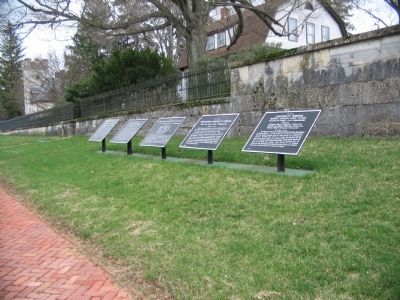
2. Confederate Tablet Cluster near the Entrance to the Cemetery
From left to right these are: Longstreet's Command, September 14-16 (number 303); Longstreet's Command, September 17 (number 304); Reserve Artillery, Longstreet's Command, September 15-16 (number 305); Hood's Division, September 15-16 (number 309); and Reserve Artillery, Hood's Division, September 15-16 (number 311). Three additional tablets stand to the right of these.

Photographed By Craig Swain, April 6, 2008
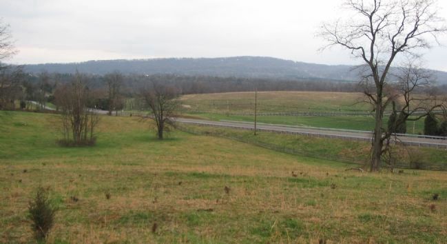
3. Longstreet's Left Flank
Leading up to the battle, Longstreet's Command fell back from South Mountain and occupied positions just outside of Sharpsburg. Looking south from the high ground just north of the National Cemetery, the Boonsboro Pike runs directly across the field of view. Longstreet dressed his left flank on the pike, with his assigned divisions guarding the southern approaches to Sharpsburg, lines extending off to the right of this photograph.
Credits. This page was last revised on November 24, 2017. It was originally submitted on April 20, 2008, by Craig Swain of Leesburg, Virginia. This page has been viewed 764 times since then and 14 times this year. Photos: 1, 2, 3. submitted on April 20, 2008, by Craig Swain of Leesburg, Virginia.
