Near Opelika in Lee County, Alabama — The American South (East South Central)
Bean's Mill
Side 1
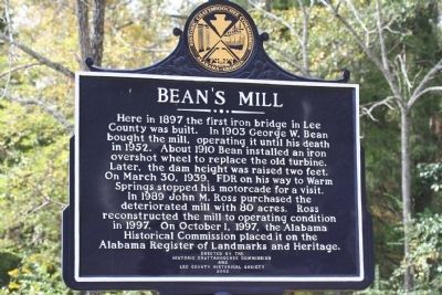
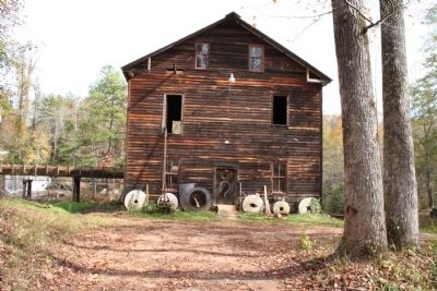
Here in 1897 the first iron bridge in Lee County was built. In 1903 George W. Bean bought the mill, operating it until his death in 1952. About 1910 Bean installed an iron overshot wheel to replace the old turbine. Later, the dam height was raised two feet. On March 30, 1939, FDR on his way to Warm Springs stopped his motorcade for a visit. In 1989 John M. Ross purchased the deteriorated mill with 80 acres. Ross reconstructed the mill to operating condition in 1997. On October 1, 1997, the Alabama Historical Commission placed it on the Alabama Register of Landmarks and Heritage.
Side 2
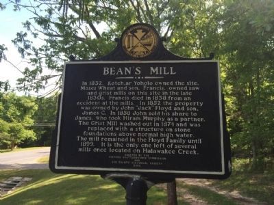
In 1832, Kotch,ar Yoholo owned the site. Moses Wheat and son, Francis, owned saw and grist mills on this site in the late 1830s. Francis died in 1838 from an accident at the mills. In 1852 the property was owned by John 'Jack' Floyd and son, James C. In 1858 John sold his share to James, who took Hiram Murphy as a partner. The Grist Mill washed out in 1874 and was replaced with a structure on stone foundations above normal high water. The mill remained in the Floyd Family until 1899. It is the only one left of several mills once located on Halawakee Creek.
Erected 2002 by the Historic Chattahoochee Commission and Lee County Historical Society.
Topics and series. This historical marker is listed in these topic lists: Industry & Commerce • Landmarks • Waterways & Vessels. In addition, it is included in the Former U.S. Presidents: #32 Franklin D. Roosevelt series list. A significant historical month for this entry is March 1764.
Location. 32° 41.822′ N, 85° 16.079′ W. Marker is near Opelika, Alabama, in Lee County. Marker is on West Point Parkway (U.S. 29 at milepost 197), 0.6 miles south of County Road 390, on the right when traveling south. Touch for map. Marker is at or near this postal address: 6247 US Highway 29 North, Opelika AL 36804, United States of America. Touch for directions.
Other nearby markers. At least 8 other markers are within 8 miles of this marker, measured as the crow flies. Shady Grove Christian Church (approx. 1˝ miles away); Pat Garrett and Billy the Kid / Pat Garrett, "The Man Who Shot Billy the Kid" (approx. 3.4 miles away); Fort Cusseta (approx. 6.4 miles away); Salem, Alabama (approx. 7 miles away); Thompson Chapel (approx. 7 miles away); Top Rock Millstone (approx. 7.1 miles away); Salem Shotwell Covered Bridge (approx. 7.1 miles away); Municipal "Monkey" Park (approx. 7.2 miles away). Touch for a list and map of all markers in Opelika.
Also see . . . "Back to the Grind -- The History of Bean's Mill." (video). YouTube (Submitted on May 8, 2014, by Mark Hilton of Montgomery, Alabama.)
Credits. This page was last revised on June 16, 2016. It was originally submitted on May 31, 2010, by L Stanford of Auburn, United States. This page has been viewed 2,154 times since then and 53 times this year. Last updated on May 8, 2014, by Mark Hilton of Montgomery, Alabama. Photos: 1. submitted on May 31, 2010, by L Stanford of Auburn, United States. 2. submitted on May 8, 2014, by Mark Hilton of Montgomery, Alabama. 3, 4. submitted on May 31, 2010, by L Stanford of Auburn, United States. • Bernard Fisher was the editor who published this page.


