Marker Logo
THE HISTORICAL
MARKER DATABASE
“Bite-Size Bits of Local, National, and Global History”
Kiskiminetas Township near Brick Church in Armstrong County, Pennsylvania — The American Northeast (Mid-Atlantic)
 

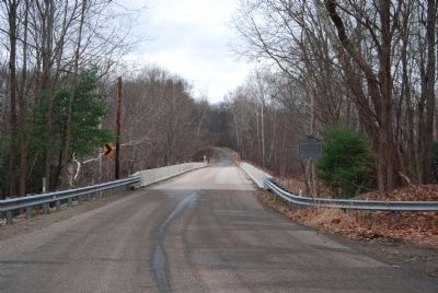
Cochran Mills Bridge
 
 
Cochran Mills Bridge Marker image. Click for full size.
May 30, 2014
1. Cochran Mills Bridge Marker
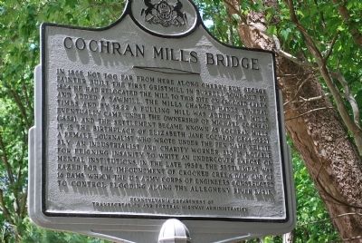
Inscription. In 1800, not too far from here along Cherry Run, George Painter built the first gristmill in Burrell Township. By 1804 he had relocated the mill to this site on Crooked Creek and added a sawmill. The mills changed hands several times and by 1822 a fulling mill was added. The mills eventually came under the ownership of Michael Cochran (1858) and the settlement became known as Cochran Mills. It is the birthplace of Elizabeth Jane Cochran (1864-1922), a female journalist who wrote under the pen name Nellie Bly. An industrialist and charity worker, Bly is notable for feigning insanity to write an undercover expose on mental institutions. In the late 1930s the settlement was razed for the impoundment of Crooked Creek Dam, one of 16 dams which the US Army Corps of Engineers constructed to control flooding along the Allegheny River basin.
 
Erected by Pennsylvania Dept. of Transportation and Federal Highway Administration.
 
Topics. This historical marker is listed in these topic lists: Arts, Letters, MusicBridges & ViaductsIndustry & CommerceSettlements & Settlers. A significant historical year for this entry is 1800.
 
Location. 40° 40.433′ N,
Paid Advertisement
Click or scan to see
this page online
79° 27.517′ W. Marker is near Brick Church, Pennsylvania, in Armstrong County. It is in Kiskiminetas Township. It is on Garretts Run Road (Pennsylvania Route SR 2025) 2 miles south of Brick Church Rd. ( Route 2005), on the right when traveling south. Touch for map. Marker is at or near this postal address: 161 State Rte 2025, Ford City PA 16226, United States of America. Touch for directions.

Regionally, this marker is in Greater Pittsburgh. It is also in the American Northeast, in the Mid-Atlantic, in Appalachia, and specifically in Northern Appalachia. Globally, it is in North America, the Western Hemisphere, the Western World, and the Anglosphere. Historically, it finds itself in what was once the Haudenosaunee (Iroquois) Confederacy and also one of the original Thirteen Colonies.

Other nearby markers. At least 8 other markers are within 8 miles of this marker, measured as the crow flies: In Honor of Nellie Bly (approx. 0.3 miles away); In Memory of Lieutenant Michael Schall, Sr. (approx. 0.4 miles away); Elderton (approx. 6.1 miles away); a different marker also named Elderton (approx. 6.4 miles
Cochran Mills Bridge Marker image. Click for full size.
Photographed by Mike Wintermantel, November 30, 2014
2. Cochran Mills Bridge Marker
away); Blanket Hill (approx. 6.7 miles away); a different marker also named Blanket Hill (approx. 6.7 miles away); Parks Township Veterans Memorial (approx. 7 miles away); Vandergrift (approx. 7.4 miles away).
 
Additional keywords. gristmill, sawmill, fulling mill
 
 
Credits. This page was last revised on October 24, 2024. It was originally submitted on June 1, 2014. This page has been viewed 2,328 times since then and 146 times this year. Photos:   1. submitted on June 1, 2014.   2. submitted on November 30, 2014, by Mike Wintermantel of Pittsburgh, Pennsylvania. • Bill Pfingsten was the editor who published this page.

m=74142

CeraNet Cloud Computing sponsors the Historical Marker Database.
This website earns income from purchases you make after using our links to Amazon.com. We appreciate your support.
Paid Advertisement
Jul. 28, 2026
