Farmingdale in Monmouth County, New Jersey — The American Northeast (Mid-Atlantic)
Charcoal Depot: warehouse & staging area
Industry & Trade Historic Settlements
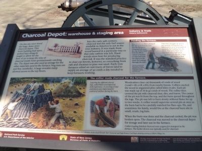
On this site once stood the huge three story charcoal depot. This brick building had open, arched bays along its length to allow for the flow of air to keep the tons of charcoal inside from spontaneously catching fire. The depot was also used as storage for the other materials used in the furnace: bog iron ore and flux (seashells). A large wooden ramp allowed access to the top floors.
Into the early 19th century, charcoal was the only fuel source available in America to use in the iron industry. It was made from wood burned in a particular way so that only carbon was left. Hardwoods were best for producing charcoal. It was the standard practice to clear cut forests, however, so everything from oak and chestnut to pine was used. Early iron furnaces relied on vast tracts of forest land to supply an average of 50 cords a day needed to keep furnaces working.
Feeding the furnace.
Men known as fillers dumped the raw materials from iron into the furnace’s charging hole near the top of the stack.* First the fillers carted 15 bushels of charcoal from the depot to the stack for loading through the hole. Then they brought up to 400 to 500 pounds of bog iron ore, followed by 30 to 40 pounds of seashells for loading into the stack. The procedure was repeated every half hour, 24 hours per day for 7 days per week to feed the furnace.
* NOTE: The illustration shown here is of a top-loading furnace. Hopewell Works had a vertical charging hole near the top of the stack.
The collier made charcoal for the furnace.
Woodcutters clear cut thousands of cords of wood (1 cord = 4 ft. x 4 ft. x 8 ft.) from nearby forests. Colliers stacked the wood in organized piles called kilns or pits. Each pit was made up of 30 to 40 cords of wood. The collier then covered the pit with charcoal dust, dirt, and leaves. The center of the pit was lit from the top, and the burn spread throughout the logs. The pit was left to burn slowly without flame for up to two weeks. A collier would supervise several pits at once as the burn had to be carefully watched for flare-ups. He, and sometimes his family, would live at the charcoal burn site in small, crude, log huts.
When the burn was done and the charcoal cooled, the pit was broken open. The charcoal was moved to the charcoal depot for storage and later use in the furnace.
Erected by State of New Jersey, National Park Service.
Topics. This historical marker is listed in these topic lists: Industry & Commerce • Settlements & Settlers.
Location. 40° 9.358′ N, 74° 7.594′ W. Marker is in Farmingdale, New Jersey, in Monmouth County. Marker can be reached from County Route 524, on the left when traveling west. Marker is located in Allaire Village in Allaire State Park. Touch for map. Marker is in this post office area: Farmingdale NJ 07727, United States of America. Touch for directions.
Other nearby markers. At least 8 other markers are within walking distance of this marker. The Furnace: heart of the village (within shouting distance of this marker); A Salute to the Boy Scouts of America (within shouting distance of this marker); Millpond (about 600 feet away, measured in a direct line); The Manasquan Floodplain (about 700 feet away); Allaire Village (approx. 0.2 miles away); Church (approx. 0.2 miles away); Allentown Station (approx. ¼ mile away); PRR Watchman’s Shanty (approx. ¼ mile away).
Also see . . . The Historic Village at Allaire. Lining Museum Website (Submitted on June 7, 2014, by Bill Coughlin of Woodland Park, New Jersey.)
Credits. This page was last revised on March 11, 2021. It was originally submitted on June 7, 2014, by Bill Coughlin of Woodland Park, New Jersey. This page has been viewed 452 times since then and 9 times this year. Photos: 1. submitted on April 23, 2015, by Bill Coughlin of Woodland Park, New Jersey. 2, 3. submitted on June 7, 2014, by Bill Coughlin of Woodland Park, New Jersey. 4. submitted on April 22, 2015, by Bill Coughlin of Woodland Park, New Jersey.


