Berlin in Coos County, New Hampshire — The American Northeast (New England)
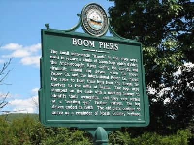
Boom Piers
Erected 1989 by New Hampshire Division of Historical Resources. (Marker Number 159.)
Topics and series. This historical marker is listed in these topic lists: Horticulture & Forestry • Industry & Commerce • Settlements & Settlers. In addition, it is included in the New Hampshire Historical Highway Markers series list. A significant historical year for this entry is 1963.
Location. 44° 29.188′ N, 71° 10.006′ W. Marker is in Berlin, New Hampshire, in Coos County. Marker is on Main Street (New Hampshire Route 16), on the right when traveling north. The marker is located in a small roadside rest area, on the east side of highway 16, overlooking the Androscoggin River. Touch for map. Marker is in this post office area: Berlin NH 03570, United States of America. Touch for directions.
Other nearby markers. At least 4 other markers are within 14 miles of this marker, measured as the crow flies. Maynesborough's First Residence (approx. 1.8 miles away); The Nansen Ski Jump (approx. 3.2 miles away); The Ravine House (approx. 9.9 miles away); Presidential Range (approx. 13.9 miles away).
More about this marker. Beyond the marker you can see the remains of the boom piers in the middle of the river.
Credits. This page was last revised on June 16, 2016. It was originally submitted on December 11, 2013, by Cosmos Mariner of Cape Canaveral, Florida. This page has been viewed 910 times since then and 86 times this year. Last updated on June 19, 2014, by Kevin Craft of Bedford, Quebec. Photos: 1. submitted on December 11, 2013, by Cosmos Mariner of Cape Canaveral, Florida. 2, 3. submitted on September 19, 2015. • Bill Pfingsten was the editor who published this page.


