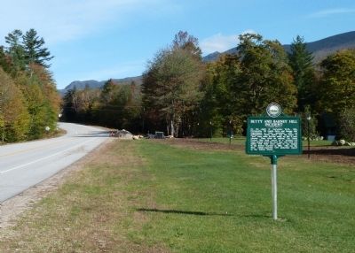
Lincoln in Grafton County, New Hampshire — The American Northeast (New England)
Betty and Barney Hill Incident
Erected 2011 by New Hampshire Division of Historical Resources. (Marker Number 224.)
Topics and series. This historical marker is listed in this topic list: Notable Events. In addition, it is included in the New Hampshire Historical Highway Markers series list. A significant historical date for this entry is September 19, 1788.
Location. 44° 5.128′ N, 71° 41.048′ W. Marker is in Lincoln, New Hampshire, in Grafton County. Marker is on Daniel Webster Highway (U.S. 3), on the right when traveling north. Marker close to the Indian Head Resort. Touch for map. Marker is in this post office area: Lincoln NH 03251, United States of America. Touch for directions.
Other nearby markers. At least 8 other markers are within 3 miles of this marker, measured as the crow flies. Franconia Range (approx. 0.8 miles away); A Bit of History (approx. 0.8 miles away); The Flume (approx. 0.8 miles away); Franconia Notch State Park (approx. 0.8 miles away); Eastern Brook Trout (approx. 0.8 miles away); a different marker also named The Flume (approx. 0.9 miles away); Clark's Bridge (approx. 2.4 miles away); Quinten E. Mulleavey (approx. 2.4 miles away). Touch for a list and map of all markers in Lincoln.
Regarding Betty and Barney Hill Incident. Writer John G. Fuller, a columnist for Saturday Review magazine, went to Exeter, New Hampshire, in the fall of 1965 to investigate several recent sightings of unidentified flying objects (UFOs) for his book, Incident at Exeter. While in Exeter he also happened to meet Betty and Barney Hill, who lived in the nearby town of Portsmouth. They told him about their own UFO encounter, four years earlier, while driving home from Canada.
The Hills had told almost no one of that traumatic night in 1961; in fact, at first they could not remember most of the details. But the experience had left them shaken and disturbed, so in 1963 they sought help from Benjamin Simon, M.D., a Boston psychiatrist. In several sessions, under hypnosis separately, Betty and Barney gave Dr. Simon eerily similar accounts of being taken aboard a spacecraft for medical and scientific exams.
Theirs remains one of the best documented UFO encounters on record, and it led to a second book by Fuller, Interrupted Journey, which came out in 1966.
Also see . . . Huffington Post article. The July 25, 2011, posting describes New Hampshire’s decision to add this marker to their official highway marker series. The story links to a video about the Hills’ strange experience, never satisfactorily explained. (Submitted on October 6, 2011, by Roger W. Sinnott of Chelmsford, Massachusetts.)
Additional keywords. UFO encounter

Photographed By Roger W. Sinnott, October 6, 2011
3. Fuller’s 1966 Book About the Hills
This book, like Incident at Exeter, became a bestseller in the 1960s.
Click for more information.
This website may earn income if you use this link to make a purchase.
Click for more information.
This website may earn income if you use this link to make a purchase.

Photographed By Roger W. Sinnott, October 6, 2011
4. View Near Entrance of Indian Head Resort
Under favorable lighting conditions, the distant rocky hilltop at top left resembles the head of an Indian chief in silhouette, and Indian Head Resort provides a good view of it. (The illusion is not unlike that of a more famous feature, 5 miles north of here, New Hampshire's Old Man of the Mountain, which collapsed in 2003.) The Betty and Barney Hill marker can be seen just left of the totem pole in this picture.
Credits. This page was last revised on September 16, 2020. It was originally submitted on October 6, 2011, by Roger W. Sinnott of Chelmsford, Massachusetts. This page has been viewed 5,537 times since then and 1,138 times this year. Last updated on June 19, 2014, by Kevin Craft of Bedford, Quebec. It was the Marker of the Week September 13, 2020. Photos: 1, 2, 3, 4. submitted on October 6, 2011, by Roger W. Sinnott of Chelmsford, Massachusetts. • Bill Pfingsten was the editor who published this page.

