Ehrhardt in Bamberg County, South Carolina — The American South (South Atlantic)
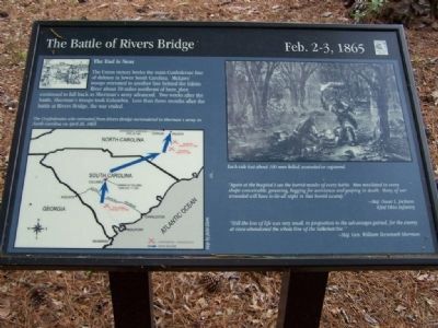
Battle of Rivers' Bridge
Feb. 2-3, 1865
The Union Victory broke the main Confederate line of defense in lower South Carolina. McLaws' troops retreated to another line behind the Edisto River about 20 miles northeast of here, then continued to fall back as Sherman's army advanced. Two weeks after the battle, Sherman's troops took Columbia. Less than three months after the battle at Rivers Bridge, the war ended.
" Again at the hospital I see the horrid results of every battle. Men mutilated in every shape conceivable, groaning, begging for assistance and gasping in death. Many of our wounded will have to lie all night in that horrid swamp." - Maj. Oscar L. Jackson 63rd Ohio Infantry
" Still the loss of life was very small, in proportion to the advantage gained, for the enemy at once abandoned the whole line of the Salkewatchie." - Maj. Gen. William Tecumseh Sherman
Erected by South Carolina State Park Service.
Topics. This historical marker is listed in this topic list: War, US Civil.
Location. 33° 3.209′ N, 81° 6.096′ W. Marker is in Ehrhardt, South Carolina, in Bamberg County. Marker can be reached from SC-S-5-8, on the right when traveling south. Located in the Rivers Bridge State Park, a mile south of SC-S-5-31. Touch for map. Marker is in this post office area: Ehrhardt SC 29081, United States of America. Touch for directions.
Other nearby markers. At least 8 other markers are within walking distance of this marker. A different marker also named Battle of Rivers' Bridge (a few steps from this marker); a different marker also named Battle of Rivers' Bridge (within shouting distance of this marker); a different marker also named Battle of Rivers' Bridge (within shouting distance of this marker); a different marker also named Battle of Rivers' Bridge (about 500 feet away, measured in a direct line); a different marker also named Battle of Rivers' Bridge (about 500 feet away); a different marker also named Battle of Rivers' Bridge (about 600 feet away); a different marker also named Battle of Rivers' Bridge (about 700 feet away); a different marker also named Battle of Rivers' Bridge (about 800 feet away). Touch for a list and map of all markers in Ehrhardt.
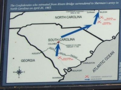
Regarding Battle of Rivers' Bridge. In the upper left is a drawing depicting the Confederate retreat. Below it is a map showing the Federal advance across South Carolina, with the caption, The Confederates who retreated from Rivers Bridge surrendered to Sherman's army in North Carolina on April 26, 1865. On the upper right is a drawing of soldiers recovering the body of a comrade from the battlefield. Each side lost 100 men killed, wounded, or captured.
Credits. This page was last revised on June 16, 2016. It was originally submitted on April 29, 2008, by Mike Stroud of Bluffton, South Carolina. This page has been viewed 1,394 times since then and 32 times this year. Photos: 1, 2. submitted on April 29, 2008, by Mike Stroud of Bluffton, South Carolina. • Craig Swain was the editor who published this page.

