Rockport in Essex County, Massachusetts — The American Northeast (New England)
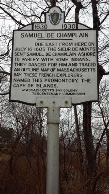
Samuel De Champlain
Erected 1930 by Massachusetts Bay Tercentenary Commission.
Topics and series. This historical marker is listed in these topic lists: Exploration • Native Americans. In addition, it is included in the Massachusetts Bay Colony—Tercentenary Commission Markers series list. A significant historical month for this entry is July 1924.
Location. 42° 39.017′ N, 70° 35.95′ W. Marker is in Rockport, Massachusetts, in Essex County. Marker is at the intersection of South St. and Whale Cove lane on South St.. Touch for map. Marker is in this post office area: Rockport MA 01966, United States of America. Touch for directions.
Other nearby markers. At least 8 other markers are within one mile of this marker, measured as the crow flies. Benjamin Tarr House (approx. 0.6 miles away); Town Wharves (approx. one mile away); Cannon from the U.S.S. Constitution (approx. one mile away); Harvey Park (approx. one mile away); Rockport World War I & II Memorial (approx. one mile away); Old Stone Fort (approx. 1.1 miles away); Straitsmouth Island (approx. 1.1 miles away); Bear Skin Neck (approx. 1.1 miles away). Touch for a list and map of all markers in Rockport.
Credits. This page was last revised on January 20, 2020. It was originally submitted on June 22, 2014, by David Remington of Rockport, Massachusetts. This page has been viewed 898 times since then and 87 times this year. Photo 1. submitted on June 23, 2014, by David Remington of Rockport, Massachusetts. • Bill Pfingsten was the editor who published this page.
