Isle La Motte in Grand Isle County, Vermont — The American Northeast (New England)
Samuel de Champlain Monument
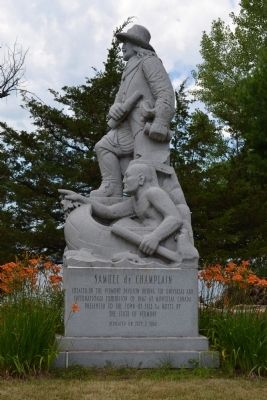
Photographed by Joe Harness, July 17, 2011
1. Samuel de Champlain Monument Marker
Topics. This historical marker and monument is listed in this topic list: Exploration. A significant historical month for this entry is July 1666.
Location. 44° 54.051′ N, 73° 20.91′ W. Marker is in Isle La Motte, Vermont, in Grand Isle County. It is on Shrine Road. Touch for map. Marker is at or near this postal address: 92 Shrine Rd, Isle La Motte VT 05463, United States of America. Touch for directions.

Regionally, this marker and monument is in Vermont’s Champlain Valley. It is also in the American Northeast and in New England. Globally, it is in North America, the Western Hemisphere, the Western World, and the Anglosphere. Historically, it finds itself in what was once the Viceroyalty of New France and also the Vermont Republic.
Other nearby markers. At least 8 other markers are within 2 miles of this marker, measured as the crow flies: Site of French Fort Ste. Anne (within shouting distance of this marker); A Place Of Pilgrimage (within shouting distance of this marker); Col. Seth Warner and Capt. Remember Baker (approx. 0.2 miles away); Sweet's Ferry (approx. 1.2 miles away); Captain Remember Baker (approx. 1.4 miles away); Isle La Motte (approx. 1.4 miles away); Gen Burgoyne (approx. 1.6 miles away in New York); Capt. de Chazy (approx. 1.7 miles away in New York). Touch for a list and map of all markers in Isle La Motte.
Credits. This page was last revised on June 14, 2025. It was originally submitted on November 7, 2011, by Joe Harness of Little Egg Harbor, New Jersey. This page has been viewed 1,358 times since then and 79 times this year. Last updated on June 23, 2014, by Kevin Craft of Bedford, Quebec. Photo 1. submitted on November 7, 2011, by Joe Harness of Little Egg Harbor, New Jersey. • Bill Pfingsten was the editor who published this page.
