Ogdensburg in St. Lawrence County, New York — The American Northeast (Mid-Atlantic)
Fort la Présentation
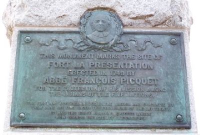
Fort la Présentation
erected in 1749 by
Abbé François Picquet
for the protection of his mission among
the Indians of the Five Nations.
The fort was occupied in 1760 by the British and evacuated by them June 1st, 1796 under the provisions of the Jay Treaty
It was the first building erected where now stands the city of Ogdensburg
———————
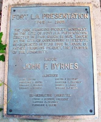
1749 - 1969
The Abbe Francois Picquet Monument on the site of Fort la Presentation erected in 1749 which is now known as the city of Ogdensburg is herewith re-dedicated in year 1969 in honor of Father Francois Picquet, the founder of the community.
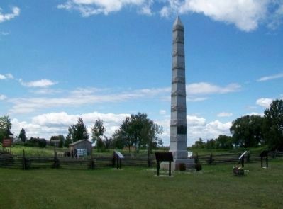
Erected 1899 by many local public/private citizens/organizations; rededicated 1969.
Topics. This historical marker is listed in these topic lists: Churches & Religion • Forts and Castles • Native Americans • Settlements & Settlers. A significant historical month for this entry is June 1812.
Location. 44° 41.667′ N, 75° 30.073′ W. Marker is in Ogdensburg, New York, in St. Lawrence County. Marker is on the Downtown Arterial (New York State Route 68) west of Commerce Street, on the right when traveling west. Touch for map. Marker is in this post office area: Ogdensburg NY 13669, United States of America. Touch for directions.
Other nearby markers. At least 8 other markers are within walking distance of this marker. Fort de la Présentation - 1749-1759 (here, next to this marker); Fort Lévis - 1760 (here, next to this marker); Fort Oswegatchie 1760-1796 (here, next to this marker); The Battle of Ogdensburg (here, next to this marker); Aka Se We':Ka Tsi (Oswegatchie) (here, next to this marker); Fort de la Présentation (here, next to this marker); Abbe Picquet 1708 -1781 (about 400 feet away, measured in a direct line); Mission Fort (about 500 feet away). Touch for a list and map of all markers in Ogdensburg.
Also see . . .
1. Fort de La Présentation. Wikipedia entry (Submitted on February 18, 2021, by Larry Gertner of New York, New York.)
2. Fort la Présentation. New York State Military Museum entry (Submitted on July 28, 2014, by William Fischer, Jr. of Scranton, Pennsylvania.)

Photographed By Larry Gertner, May 15, 2021
4. Fort de la Présentation
Museum website homepage
Click for more information.
Click for more information.
Credits. This page was last revised on May 25, 2023. It was originally submitted on July 28, 2014, by William Fischer, Jr. of Scranton, Pennsylvania. This page has been viewed 488 times since then and 31 times this year. Photos: 1, 2, 3. submitted on July 28, 2014, by William Fischer, Jr. of Scranton, Pennsylvania. 4. submitted on May 15, 2021, by Larry Gertner of New York, New York.


