Fort Montgomery in Orange County, New York — The American Northeast (Mid-Atlantic)
The Naval Battle of Fort Montgomery
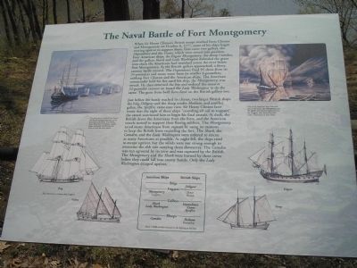
When Sir Henry Clinton’s British troops reached Forts Clinton and Montgomery on October 6, 1777, some of his ships began moving upriver to support them. First came two galleys, the Dependence and the Crane, which were rowed into position. Four American ships, the frigate Montgomery, the sloop Camden, and the galleys Shark and Lady Washington defended the giant iron chain the Americans had stretched across the river below Fort Montgomery. As the British galleys approached, a fierce cannon battle ensued. The Dependence fired 95 shots from its 24-pounders and many more from its smaller 6-pounders, striking Fort Clinton and the American ships. The American commander held his fire until his ship, the Montgomery, was struck. He then returned the fire and ordered the massive 32-pounder cannon on board the Lady Washington to do the same. The guns from both forts fired on the British galleys too.
Just before the battle reached its climax, two larger British ships, the brig Diligent and the sloop tender Hotham, and another galley, the Spitfire, came into view. Sir Henry Clinton later wrote that the sight of these ships “crowding all sail to support” the attack convinced him to begin his final assault. At dusk, the British drove the Americans from the forts, and the American vessels turned to support their fleeing soldiers. The Montgomery saved many Americans from capture by using its cannons to keep the British from encircling the fort. The Shark, the Camden, and the Lady Washington were ordered to rescue as many Americans as possible. As night fell, the ships tried to escape upriver, but the winds were not strong enough to overcome the ebb tide carrying them downriver. The Camden was run aground by its crew and was captured by the British. The Montgomery and the Shark were burned by their crews before they could fall into enemy hands. Only the Lady Washington escaped upriver.
Erected by Fort Montgomery State Historic Site.
Topics. This historical marker is listed in these topic lists: Forts and Castles • War, US Revolutionary. A significant historical month for this entry is October 1958.
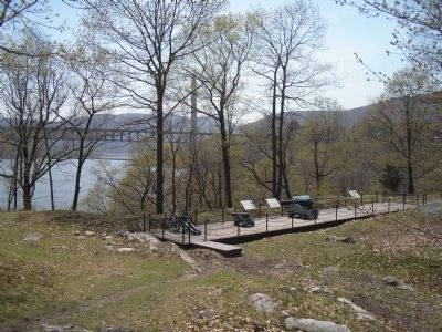
Location. 41° 19.438′ N, 73° 59.162′ W. Marker is in Fort Montgomery, New York, in Orange County. Marker can be reached from State Highway 9W. Marker is in Fort Montgomery State Historic Site on the walking trail, overlooking the Hudson River. Touch for map. Marker is in this post office area: Fort Montgomery NY 10922, United States of America. Touch for directions.
Other nearby markers. At least 8 other markers are within walking distance of this marker. 32-Pounder (here, next to this marker); a different marker also named The Naval Battle of Fort Montgomery
(a few steps from this marker); Grand Battery (a few steps from this marker); Three Sisters Garden (about 300 feet away, measured in a direct line); Gardens of the Fort (about 300 feet away); Powder Magazine (about 300 feet away); Fort Montgomery Today (about 400 feet away); Building a Fort (about 400 feet away). Touch for a list and map of all markers in Fort Montgomery.
More about this marker. The upper left of the marker features an “illustration by Jack Mead depict[ing] the British landing force early on the morning of the battle. The British had a large fleet of warships, supply ships, transports, and flat-bottom boats to carry the men ashore.”
The upper right of the marker features a picture of “Two of the American ships that took part in the battle, the Montgomery and the Shark, and another frigate upriver, the Congress, [that] were burned by their crew. Illustration by Jack Mead.”
Sidebar: A listing of the ships present at the battle is at the bottom of the marker. These include American Frigates Montgomery and Congress, American Galleys
Shark and Lady Washington and Sloop Camden. British ships listed are the Brig Diligent, Frigates Tartar and Preston, Galleys Dependence, Crane and Spitfire, and Sloops Hotham and Friendship.
Illustrations of the various types of ships appear on the marker. Ship illustrations are by Jack Coggins.
Also see . . . The Battle of Fort's (sic) Montgomery and Clinton. The American Revolutionary War website entry (Submitted on April 27, 2008, by Bill Coughlin of Woodland Park, New Jersey.)
Credits. This page was last revised on August 19, 2021. It was originally submitted on April 27, 2008, by Bill Coughlin of Woodland Park, New Jersey. This page has been viewed 1,859 times since then and 28 times this year. Last updated on May 5, 2008, by Bill Coughlin of Woodland Park, New Jersey. Photos: 1, 2, 3. submitted on April 27, 2008, by Bill Coughlin of Woodland Park, New Jersey. 4. submitted on October 11, 2015, by Bill Coughlin of Woodland Park, New Jersey. 5. submitted on April 27, 2008, by Bill Coughlin of Woodland Park, New Jersey. • Kevin W. was the editor who published this page.


