Columbiana in Shelby County, Alabama — The American South (East South Central)
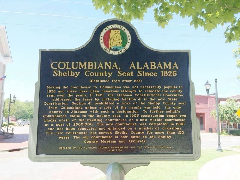
Columbiana, Alabama
Shelby County Seat Since 1826

Photographed by Mark Hilton, August 14, 2014
1. Columbiana, Alabama Marker (side 1)
Side 1
Columbiana, originally called Columbia, was selected as the county seat of Shelby County in 1826 over rivals Calera and Montevallo. After the selection as the county seat, Columbiana celebrated by drilling holes in a large pine tree and packing it with gunpowder. The tree was blown up and the sound could be heard for miles. Later in 1826, the courthouse was moved to an old school building in Columbiana. An act of the Alabama Legislature officially changed the name of Shelby’s county seat to Columbiana on January 13, 1832. Columbiana was incorporated on December 5, 1837 with corporate limits one-quarter of a mile in each direction from the public square. In 1854, the decision was made to build a larger courthouse at the south end of “Silk Stocking Road,” now Main Street. From 1854 to 1908, several additions and changes were made to the courthouse.
this page online
Erected 2010 by the Alabama Tourism Department and the City of Columbiana.
Topics and series. This historical marker is listed in this topic list: Settlements & Settlers. In addition, it is included in the Alabama Tourism Department series list. A significant historical month for this entry is January 1889.
Location. 33° 10.64′ N, 86° 36.415′ W. Marker is in Columbiana, Alabama, in Shelby County. It is at the intersection of North Main Street (County Road 47) and Mildred Street, on
Photographed by Mark Hilton, August 14, 2014
2. Columbiana, Alabama Marker

Regionally, this marker is in the Birmingham Metropolitan Area. It is also in the American South and specifically in the Deep South. Globally, it is in North America, a Gulf of Mexico state, the Western Hemisphere, the Western World, and the Anglosphere. Historically, it finds itself in what was once New Spain, the territory of the Mississippian Culture, one of the Confederate States of America, and the Antebellum South.
Other nearby markers. At least 8 other markers are within 9 miles of this marker, measured as the crow flies: Shelby Furnaces (here, next to this marker); Shelby County Courthouse (within shouting distance of this marker); Shelby County War Memorial (about 500 feet away, measured in a direct line); Steam Engine (approx. 4.6 miles away); Machine Shop Smoke Stack (approx. 4.6 miles away); Calera & Shelby Railroad (approx. 4.6 miles away); Shelby Springs Confederate Cemetery (approx. 5.4 miles away); Lesters Chapel United Methodist Church

Photographed by Mark Hilton, August 14, 2014
3. Old Shelby County Courthouse near marker.
Now Shelby County Museum & Archives.
Related marker. Click here for another marker that is related to this marker.
Also see . . . Columbiana. Encyclopedia of Alabama article (Submitted on August 14, 2014, by Mark Hilton of Montgomery, Alabama.)

Photographed by Mark Hilton, August 14, 2014
4. Looking East towards marker & Mildred Street

Photographed by Mark Hilton, August 14, 2014
5. Current Shelby County Courthouse
At Main & Depot Streets.
Credits. This page was last revised on October 13, 2026. It was originally submitted on August 14, 2014, by Mark Hilton of Montgomery, Alabama. This page has been viewed 1,209 times since then and 69 times this year. Photos: 1. submitted on August 14, 2014, by Mark Hilton of Montgomery, Alabama. 2. submitted on October 13, 2026, by Mark Hilton of Montgomery, Alabama. 3, 4, 5. submitted on August 14, 2014, by Mark Hilton of Montgomery, Alabama. • Bernard Fisher was the editor who published this page.
