Independence in Tangipahoa Parish, Louisiana — The American South (West South Central)
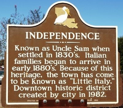
Independence
Erected 1982 by the Louisiana Dept. of Commerce and Tourism.
Topics. This historical marker is listed in this topic list: Settlements & Settlers. A significant historical year for this entry is 1982.
Location. 30° 38.134′ N, 90° 30.052′ W. Marker is in Independence, Louisiana, in Tangipahoa Parish. Marker is at the intersection of West Railroad Avenue (U.S. 51) and West 4th Street, on the right when traveling north on West Railroad Avenue. Touch for map. Marker is at or near this postal address: 539 West Railroad Ave, Independence LA 70443, United States of America. Touch for directions.
Other nearby markers. At least 8 other markers are within 10 miles of this marker, measured as the crow flies. Loranger High School (approx. 6.1 miles away); C.P.'s Station (approx. 6.4 miles away); Church of the Incarnation (approx. 6˝ miles away); Blythewood Plantation (approx. 6.6 miles away); The Republic of West Florida (approx. 8 miles away); Site of 1st Classroom Bldg. (approx. 8.7 miles away); Friendship Circle (approx. 8.8 miles away); Grace Memorial Episcopal Church (approx. 9.2 miles away).
Credits. This page was last revised on June 16, 2016. It was originally submitted on November 20, 2011, by Jeff Lovorn of Florence, Mississippi. This page has been viewed 554 times since then and 12 times this year. Last updated on August 28, 2014, by Mark Hilton of Montgomery, Alabama. Photo 1. submitted on November 20, 2011, by Jeff Lovorn of Florence, Mississippi. • Bill Pfingsten was the editor who published this page.
Editor’s want-list for this marker. A wide shot of the marker and its surroundings. • Can you help?
