Atlantic Beach in Carteret County, North Carolina — The American South (South Atlantic)
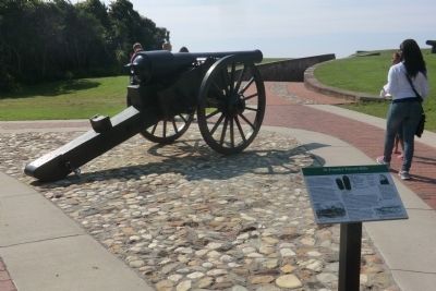
30-Pounder Parrott Rifle
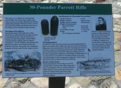
The Siege of Fort Macon
During the siege of Fort Macon in 1862, Union forces used batteries of siege cannons to bombard the fort. One of these was a battery of three 30-pounder Parrott Rifles, commanded by Captain Lewis O. Morris, Company C, 1st U.S. Artillery. The battery was placed in position over three-fourths of a mile from the fort, along with two additional batteries of 8-inch and 10-inch siege mortars.
The Bombardment
On April 25, 1862, the three Union batteries bombarded Fort Macon for eleven hours. With their great accuracy, the Parrott Rifles were very destructive to the fort, knocking out many of the fort’s walls. Repeated hits by the Parrotts cracked the walls and ceiling of one of the forts gunpowder magazines. Defending Confederates had no choice but to surrender or risk being blown up by their own gunpowder in the endangered magazine. Union forces took possession of the fort the next morning.
Historic Achievement
The bombardment of Fort Macon was the second time in history that rifled siege guns were used against a fort in combat. Because rifled cannons such as the Parrott had the power to destroy brick and stone walls, forts now became obsolete as a way of military defense.
Specifications for 30-pounder Parrott Rifle
Length of Barrel 11 feet
Weight of Barrel 4200 pounds
Weight of Gun Carriage 2350 pounds
Weight of Ammunition
Bolt (Solid Shot) 30 pounds
Shell 29 pounds
Gunpowder Charge 3¼ pounds
Range 2.7 miles
(at 15 degrees elevation)
(sidebar)
Robert P. Parrott invented a system of rifled artillery for the Union Army during the War Between the States. “Parrott Rifles” were made in different calibers from 10-pounder to 300-pounder sea coast cannons. They are characterized by the thick iron band reinforcing the cannon’s breech
(captions)
(lower left) Captain Lewis O. Morris’ Parrott Rifle battery bombarding Fort Macon on April 25, 1862.
(upper center) 30-pounder Parrott Rifle ammunition: Bolt, left; Shell, right.
(lower right) The damaged western wall of Fort Macon after the bombardment of April 25, 1862, showing the effects of cannon fire from the Parrott Rifle battery.
Topics. This historical marker is listed in these topic lists: Forts and Castles • War, US Civil. A significant historical month for this entry is April 1893.
Location. 34° 41.821′ N, 76° 40.731′ W. Marker is in Atlantic Beach, North Carolina, in Carteret County. Marker can be reached from East Fort Macon Road (County Route 1190) 3.6 miles east of Atlantic Beach Causeway (County Route 1182). This marker is on the grounds of Fort Macon State Park. Touch for map. Marker is at or near this postal address: 2303 East Fort Macon Road, Atlantic Beach NC 28512, United States of America. Touch for directions.
Other nearby markers. At least 8 other markers are within walking distance of this marker. Officers Quarters at Fort Macon (within shouting distance of this marker); World War II Barracks Area (within shouting distance of this marker); The Military Post of Fort Macon in the Nineteenth Century (within shouting distance of this marker); Cistern (within shouting distance of this marker); Fort Macon in the 1920s and 1930s (within shouting distance of this marker); World War II Defenses (within shouting distance of this marker); Bogue Banks Lighthouse (within shouting distance of this marker); Carronade Battery (within shouting distance of this marker). Touch for a list and map of all markers in Atlantic Beach.
Also see . . . Fort Macon State Park. N.C. Division of Parks & Recreation (Submitted on September 15, 2014.)
Credits. This page was last revised on June 16, 2016. It was originally submitted on September 12, 2014, by Don Morfe of Baltimore, Maryland. This page has been viewed 870 times since then and 85 times this year. Photos: 1, 2, 3. submitted on September 12, 2014, by Don Morfe of Baltimore, Maryland. • Bernard Fisher was the editor who published this page.


