Whitsett in Guilford County, North Carolina — The American South (South Atlantic)
Wadsworth Church
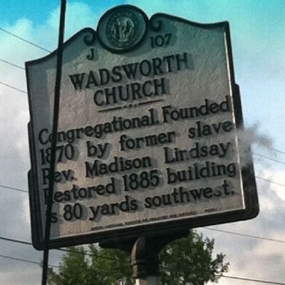
Photographed by Jessica Emerson, September 13, 2014
1. Wadsworth Congregational Church Marker
Erected 2004 by North Carolina Division of Archives and History. (Marker Number J-107.)
Topics and series. This historical marker is listed in these topic lists: African Americans • Religion & Religious Structures. In addition, it is included in the North Carolina Division of Archives and History series list. A significant historical year for this entry is 1870.
Location. 36° 2.826′ N, 79° 35.946′ W. Marker is in Whitsett, North Carolina, in Guilford County. It is at the intersection of Rock Creek Dairy Road and Judge Adams Road (County Route 3058), on the left when traveling south on Rock Creek Dairy Road. Touch for map. Marker is at or near this postal address: 1301 Rock Creek Dairy Rd, Whitsett NC 27377, United States of America. Touch for directions.

Regionally, this marker is in the Piedmont and specifically in Piedmont Triad. It is also in the American South and specifically in the Upper South. Globally, it is in North America, the Western Hemisphere, the Western World, and the Anglosphere.
this page online
Other nearby markers. At least 8 other markers are within 2 miles of this marker, measured as the crow flies: Cedar Hill Foundry and Machine Shop (approx. 0.6 miles away); McLean House (approx. 1.8 miles away); Athletics (approx. 1.9 miles away); Galen Stone Dormitory & Massachusetts Congregational Cottage (approx. 1.9 miles away); Tea House (approx. 1.9 miles away); Kimball Hall (approx. 1.9 miles away); Science at Palmer & Stouffer Hall (approx. 1.9 miles away); Devastating Fire (approx. 1.9 miles away).
Other markers no longer nearby. Athletic Field (was approx. 1.8 miles away but has been replaced with another marker now near it); Bell Tower (was approx. 1.9 miles away but has been permanently removed); Galen L. Stone Hall 1927 (was approx. 1.9 miles away but has been replaced with another marker now near it); a different marker also named Kimball Hall (was approx. 1.9 miles away but has been replaced with another marker
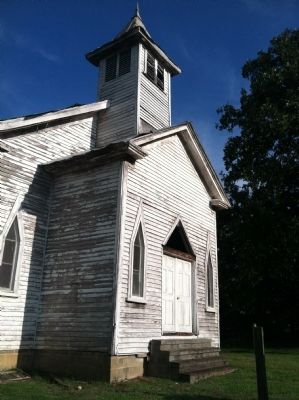
Photographed by Jessica Emerson, September 13, 2014
2. Wadsworth Congregational Church
Regarding Wadsworth Church. Actual restored Gothic church building is located behind new church. Visible from Judge Adams Rd. Access from Judge Adams Rd. or Rock Creek Dairy Rd.
Credits. This page was last revised on June 30, 2021. It was originally submitted on September 19, 2014, by Jessica Emerson of Greensboro, North Carolina. This page has been viewed 885 times since then and 31 times this year. Photos: 1, 2. submitted on September 19, 2014, by Jessica Emerson of Greensboro, North Carolina. • Bernard Fisher was the editor who published this page.
