Dyckesville in Kewaunee County, Wisconsin — The American Midwest (Great Lakes)
Stage House
⎯⎯⎯
Dyckesville
Photographed by K. Linzmeier, September 18, 2014
1. Stage House · Dyckesville Marker
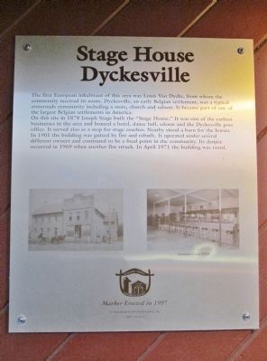
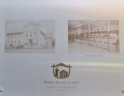
On this site in 1878 Joseph Stage built the "Stage House." It was one of the earliest businesses in the area and housed a hotel, dance hall, saloon and the Dyckesville post office. It served also as a stop for stage coaches. Nearby stood a barn for the horses. In 1901 the building was gutted by fire and rebuilt. It operated under several different owners and continued to be a focal point in the community. Its demise occurred in 1969 when another fire struck. In April 1971 the building was razed.
Erected 1997 by the Kewaunee County Historical Society.
Topics. This historical marker is listed in these topic lists: Industry & Commerce • Settlements & Settlers. A significant historical month for this entry is April 1971.
Location. 44° 38.586′ N, 87° 45.639′ W. Marker is in Dyckesville, Wisconsin, in Kewaunee County. It can be reached
this page online

Regionally, this marker is on the Door Peninsula. It is also in the American Midwest and in the Corn Belt. Globally, it is in North America, on the Great Lakes, in the Western Hemisphere, in the Western World, and in the Anglosphere. Historically, it finds itself in what was once the territory of the Mississippian Culture and also the Northwest Territory.
Other nearby markers. At least 8 other markers are within 8 miles of this marker, measured as the crow flies: Nicolet Landing (approx. 5.6 miles away); 1634 • 1909 (approx. 5.7 miles away); The 1858 Rosiere Kermiss (approx. 7.6 miles away); Bank of Luxemburg (approx. 7.7 miles away); Red Banks (approx. 7.7 miles away); The WIS 57 Reconstruction Project in Brown, Kewaunee, and Door Counties (approx. 7.8 miles away); Namur and the Norbertine Fathers: Community, Education, and Religion among Belgian-Americans
Photographed by K. Linzmeier, September 18, 2014
2. Close-up of Photos
More about this marker.
photo caption: Interior Circa 1930
Also see . . . Dyckesville, Wisconsin. Wikipedia entry. (Submitted on September 20, 2014.)
Photographed by K. Linzmeier, September 18, 2014
3. Stage House · Dyckesville Marker
Photographed by K. Linzmeier, September 18, 2014
4. Bank of Luxemburg
Credits. This page was last revised on December 7, 2024. It was originally submitted on September 20, 2014, by Keith L of Wisconsin Rapids, Wisconsin. This page has been viewed 1,128 times since then and 88 times this year. Photos: 1, 2, 3, 4. submitted on September 20, 2014, by Keith L of Wisconsin Rapids, Wisconsin.
