Near Kewaunee in Kewaunee County, Wisconsin — The American Midwest (Great Lakes)
Dikeman
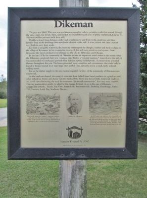
The year was 1863. This area was a wilderness accessible only by primitive trails that wound through the vast, virgin pine forest. Here, surrounded by thousands of acres of prime timberland, Charles W. Dikeman and his partners built their mill.
Unable to travel long distances under such conditions to and from work, employees and their families lived in the dwellings that were built adjacent to the mill. A store, tavern and later a school were built to meet their needs.
Far from a navigable waterway, the necessity to transport their shingles, lumber and bark overland to the village of Kewaunee led to a somewhat improved, but still very primitive road system. From Kewaunee the forest products were shipped via the lake to Milwaukee and Chicago.
In the late 1870s the community of Dikeman became an important social center in the county when the Dikemans completed their new residence described as a "palatial mansion." Located near the mill, it was surrounded by landscaped grounds that included spring-fed fishponds. A conservatory provided flowers throughout the year. The house possessed many amenities and conveniences that could only be found in houses located in or near large cities at that time, certainly not in a small, fairly isolated milling center.
But as the timber supply in the area became depleted the days of the community of Dikeman were numbered...
As the land was cleared, the county's economic base shifted from forest products to agriculture and other industries. Farm and cheese factories replaced the forest and the sawmills. Improved roadways cut travel time eliminating the need for numerous "crossroad communities" that once were essential. Thriving communities unable to adapt to the change declined or, as in the case of Dikeman, disappeared entirely... Alaska, Bay View, Bottkolville, Bruemmerville, Darbellay, Footbridge, Forest Hill, Foscoro, Sandy Bay, Scarboro, Slovan...
Erected 2002 by the Kewaunee County Historical Society.
Topics. This historical marker is listed in these topic lists: Industry & Commerce • Settlements & Settlers. A significant historical year for this entry is 1863.
Location. 44° 27.478′ N, 87° 36.435′ W. Marker is near Kewaunee, Wisconsin, in Kewaunee County. Marker is at the intersection of County Highway F and Dikeman Lane, on the left when traveling west on County Highway F. Marker is approximately 5 driving miles from Kewaunee. Touch for map. Marker is in this post office area: Kewaunee WI 54216, United States of America. Touch for directions.
Other nearby markers. At least 8 other markers are within 6 miles of this marker, measured as the crow flies. The Old Mill (approx. 2.4 miles away); Kewaunee County Lime Kilns (approx. 2.8 miles away); Kewaunee Marsh Arsenic Spill Area (approx. 4.6 miles away); Rogation Shrines (approx. 4.8 miles away); Courthouse Square (approx. 5 miles away); Civil War and Cuban Veterans Monument (approx. 5.1 miles away); The Great Kewaunee Fire (approx. 5.2 miles away); Early History of Kewaunee (approx. 5.2 miles away). Touch for a list and map of all markers in Kewaunee.
More about this marker. captions:
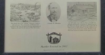
• This sketch shows the "palatial" Dikeman residence, mill and store. The community of Dikeman was located to the west of what is now the intersection of Highways B and F in the town of West Kewaunee.
• Charles W. Dikeman
• An 1876 plat map indicates that a sawmill was located on property owned by A. Hassel west of the Dikeman shingle mill but on the north side of what is now County Road F. In the 1880s it was owned by the Brumeister family. Brothers Carl, Fred and Ernst are seated on the logs to the left.
Credits. This page was last revised on June 16, 2016. It was originally submitted on September 23, 2014, by Keith L of Wisconsin Rapids, Wisconsin. This page has been viewed 480 times since then and 15 times this year. Photos: 1, 2, 3. submitted on September 23, 2014, by Keith L of Wisconsin Rapids, Wisconsin.


