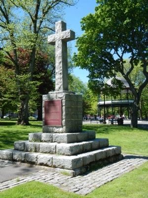
Saint John in Saint John County, New Brunswick — The Atlantic Provinces (North America)
Founding of New Brunswick
La Fondation du Nouveau-Brunswick
The increase of population consequent upon the large influx of Loyalists in 1783 and 1784 convinced the British government of the desirability of creating the Province of New Brunswick. This was done on 16 August 1784. Brigadier General Thomas Carleton, who had provided invaluable service in transplanting the United Empire Loyalists, was chosen as the province’s first governor. He arrived at Saint John on 21 November 1784, and on the following day held his first council and proclaimed Civil Government.
French
L’accroissement de la population à la suite de l’arrivée en masse des Loyalistes en 1783 et 1784 convainquit le gouvernement britannique de l’opportunité de constituer la province du Nouveau-Brunswick, ce qui fut fait le 16 août 1784. Le général Thomas Carleton, qui rendit d’inestimables services lors de l’établissement de Loyalistes, devint la premier gouverneur de la province. Il arriva à Saint-Jean le 21 novembre 1784, convoqua son premier conseil le lendemain et proclama le gouvernement civil.
Erected by Historic Sites and Monument Board of Canada/Commission de lieux et monuments historique du Canada.
Topics and series. This historical marker is listed in this topic list: Settlements & Settlers. In addition, it is included in the Canada, Historic Sites and Monuments Board series list. A significant historical date for this entry is November 21, 1784.
Location. 45° 16.41′ N, 66° 3.422′ W. Marker is in Saint John, New Brunswick, in Saint John County. Marker is on Sydney Street close to Kings Square North, on the left when traveling north. Touch for map. Marker is in this post office area: Saint John NB E2L, Canada. Touch for directions.
Other nearby markers. At least 8 other markers are within walking distance of this marker. No. 2 Mechanics’ Volunteer Company Engine House (here, next to this marker); Saint John’s Original Burial Ground (here, next to this marker); Imperial Theatre (within shouting distance of this marker); Saint John’s First Wind Grist Mill (about 90 meters away, measured in a direct line); King’s Square (about 120 meters away); King Edward VII Memorial Bandstand (about 120 meters away); Saint John City Market (about 180 meters away); The Great Fire of 1877 | L’incendie de 1877 (approx. 0.3 kilometers away). Touch for a list and map of all markers in Saint John.
Also see . . . New Brunswick - Wikipedia. Nova Scotia was therefore partitioned. In 1784, Britain split the colony of Nova Scotia into three separate colonies: New Brunswick, Cape Breton Island, and present-day peninsular Nova Scotia, in addition to the adjacent colonies of St.
John's Island (renamed Prince Edward Island in 1798) and Newfoundland. The Colony of New Brunswick was created on August 16, 1784; Sir Thomas Carleton was appointed as Lieutenant-Governor in 1784, and in 1785 a new assembly was established with the first elections. The new colony was almost called New Ireland after a failed attempt to establish a colony of that name in Maine during the war. (Submitted on September 28, 2014, by Barry Swackhamer of Brentwood, California.)
Credits. This page was last revised on June 16, 2016. It was originally submitted on September 27, 2014, by Barry Swackhamer of Brentwood, California. This page has been viewed 379 times since then and 16 times this year. Photos: 1, 2. submitted on September 28, 2014, by Barry Swackhamer of Brentwood, California. • Andrew Ruppenstein was the editor who published this page.

