Halifax in Halifax Region, Nova Scotia — The Atlantic Provinces (North America)
Fort Needham Memorial Park
and the Halifax Explosion
Left side
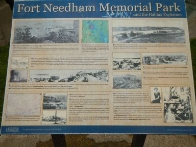
• This view from Fort Needham was drawn and engraved by Lieutenant Colonel Edward Hick, a British officier stationed in Halifax with the 70th Regiment of Foot from 1778 to 1782. The fort consisted of wooden buildings, for the defence of the Dockyard. Later fortifications, on George’s Island, Point Pleasant and the Citadel made Fort Needham of less importance and the fort was allowed to deteriorate, leaving little trace.
• Fort Needham is part of the field of egg-shaped hills or drumlins left from glaciers that crossed the region c. 20,000 years ago. The topographic map shows the site of Fort Needham (marked with (bell)) and water depth of the harbour.
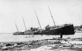
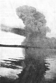
On the morning of December, 6, 1917, two ships, the Norwegian Imo and the French Mont- Blanc, which carried a full cargo of munitions bound for the war in France, collided. Sparks ignited the barrels of benzol on its deck. The fire quickly spead to the munitions, causing a spectacular cloud of smoke and flashes of flame. The burning ship remained afloat for nearly twenty minutes, drifting ever closer to the busy docks and to Richmond. This gave time for people, seemingly unaware of the danger, to gather, some on Fort Needham, to watch the exciting spectacle. Seconds before 9:05 a.m., touching Pier 6, Mont-Blanc exploded, its thick steel shattering into fragments that flew over a radius of more than three miles.
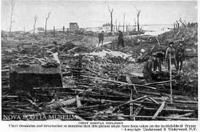
• A thick, oily fog covered the area. Wooden houses were smashed, factories destroyed, adding to the toll of death and injuries. Final figures, in this - the largest pre-atomic man-made explosion, listed over two thousand killed, many thousand injured, nine thousand left homeless.
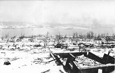
• The area of complete devastation lay around Fort Needham like an apron. S.S. Imo was beached against the Dartmouth shore.
• The map produced for the Halifax Relief Commission created in January 1918 to take over relief organization, shows the extent of the devastation and damage of the explosion.
• Crews cleared up the wreckage of all that remained of the once thriving district of Richmond.
• Construction of the row of streets and the stores between Novalea Drive (formerly Gottingen Street), where it borders Fort Needham, and Isleville Street began in September 1918. They were built of blocks of a type of cement, called hydrostone. The
material gave this district its name …The Hydrostone. The design was by British planner Thomas Adams, known for garden cities. Houses, originally for those who had been left homeless, and stores, were rented by the Halifax Relief Commission for over fifty years before being sold. The Commission gave the funds to create the Fort Needham Memorial Park.
Right side
•The 1910 Panorama for the Dartmouth Shore shows the settlement known as Richmond. Industries, railway and docks had been built along the harbour, giving plentiful employment. Among them was the Acadia Sugar Refinery, the tallest building east of Montreal (center of panorama). There were churches, schools and variety of stores.
•Damage to the houses on this part of Gottingen Street, sheltered by Fort Needham, was very serious, but they did not catch fire.
•The snowstorm that began on December 7 covered the devastation and made rescue work more difficult. These ruins are the remains of the Acadia Sugar Refinery.
•Postcards, like this one of Hills & Sons Foundry, where forty one workers died, were issued soon after the event.
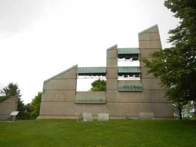
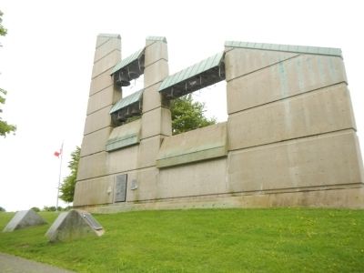
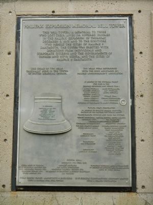
•Four churches were demolished in the blast. Presbyterians and Methodists later decided to share one new building. It became the United Memorial Church. In its towner was hung a carillon of bells, given by Barbara Orr, in memory of her mother, father, two sisters and three brothers, all of whom were killed. The family home and printing works were wrecked. The weight and vibration prove too much for the towner, and the bells were removed. In 1985 the new tower was dedicated. Designed by Keith Graham, it represented the jagged ruins, and with is upward thrust, hope for the future. As she had done in 1921, Barbara once more played the carillon, this time on a keyboard inside the towner, not with great levers as before. The Memorial Bell Tower overlooks Richmond Street, which leads to the site of the former Pier 6, where the burning ship blew up, and also the reconstructed area that was once Richmond, destroyed in the Halifax Explosion of December 6, 1917.
Erected by Halifax Regional Municipality.
Topics. This historical marker is listed in these topic lists: Disasters • Forts and Castles • War, World I. A significant historical month for this entry is January 1918.
Location. 44° 39.953′ N, 63° 36.071′ W. Marker is in Halifax, Nova Scotia, in Halifax Region. Marker can be reached from Union Street close to Kenny Street, on the left when traveling north. Touch for map. Marker is at or near this postal address: 3276 Union Street, Halifax NS B3K, Canada. Touch for directions.
Other nearby markers. At least 8 other markers are within 3 kilometers
of this marker, measured as the crow flies. Captain / Capitaine James Cook (within shouting distance of this marker); Izaak Walton & Dorothy Johnston Killam (approx. 1.8 kilometers away); Halifax Explosion Unidentified Dead (approx. 1.8 kilometers away); Fairview Lawn Cemetery (approx. 1.9 kilometers away); Halifax and RMS Titanic (approx. 1.9 kilometers away); Vera B. Stone (approx. 2.4 kilometers away); Canadian Military Engineers/Génie militaire canadien (approx. 2.4 kilometers away); "Bridges for Canada"/« Ponts pour le Canada » (approx. 2.4 kilometers away). Touch for a list and map of all markers in Halifax.
More about this marker. This marker is in the center of Fort Needham Memorial Park near the bell tower.
Also see . . .
1. The Halifax Explosion - CBC. This website will take you through that terrible day and the days that followed. It will show how the Halifax Explosion and the hard lessons it taught affect our lives today.
You will meet the heroes, the survivors, and families whose lives were changed in a great flash of light just after 9 a.m. on that December day. (Submitted on October 13, 2014, by Barry Swackhamer of Brentwood, California.)
2. Halifax Explosion - Wikipedia. By 1917, the population of Halifax/Dartmouth had grown to 65,000 people. Convoys carried soldiers, men, animals and supplies to the European theatre. By 1917, the two main points of departure were on the East Coast at Sydney (HMCS Landsdowne) in Cape Breton and Halifax. As well, hospital ships returned the wounded. (Submitted on October 13, 2014, by Barry Swackhamer of Brentwood, California.)
3. More details about this 14-bell chime. (Submitted on September 5, 2020, by Carl Scott Zimmerman of Kirkwood, Missouri.)
Credits. This page was last revised on September 10, 2020. It was originally submitted on October 13, 2014, by Barry Swackhamer of Brentwood, California. This page has been viewed 932 times since then and 35 times this year. It was the Marker of the Week December 6, 2015. Photos: 1, 2, 3, 4, 5, 6, 7, 8. submitted on October 13, 2014, by Barry Swackhamer of Brentwood, California. • Andrew Ruppenstein was the editor who published this page.
