Ash Grove in Greene County, Missouri — The American Midwest (Upper Plains)
First Permanent Home of Bank of Ash Grove, Mo
1884 - 1932
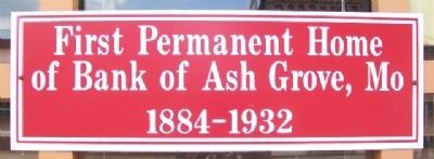
Photographed by William Fischer, Jr., March 18, 2012
1. First Permanent Home of Bank of Ash Grove, Mo Marker
Topics. This historical marker is listed in this topic list: Notable Buildings.
Location. 37° 18.92′ N, 93° 35.108′ W. Marker is in Ash Grove, Missouri, in Greene County. It is on Main Street west of Calhoun Avenue (Road F), on the left when traveling west. Marker is at the Ozarks Afro-American Museum Heritage Museum. Touch for map. Marker is at or near this postal address: 107 West Main Street, Ash Grove MO 65604, United States of America. Touch for directions.

Regionally, this marker is in Greater Springfield. It is also in the American Ozarks, in the Lewis & Clark Corridor, and in the Corn Belt. Globally, it is in North America, the Western Hemisphere, the Western World, and the Anglosphere. Historically, it finds itself in what was once the territory of the Mississippian Culture, the Louisiana Purchase, and the Antebellum South.
Other nearby markers. At least 8 other markers are within 17 miles of this marker, measured as the crow flies: Nathan Boone Cabin (approx. 2.2 miles away); Gary's Gay Parita, Gay Parita, Missouri (approx. 9.8
this page online
Also see . . . Ozarks Afro-American Heritage Museum Online. (Submitted on December 20, 2014, by William Fischer, Jr. of Reynoldsburg, Ohio.)
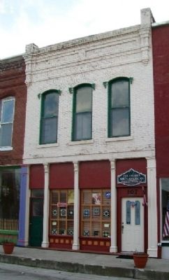
Photographed by William Fischer, Jr., March 18, 2012
2. First Permanent Home of Bank of Ash Grove, Mo and Marker
Credits. This page was last revised on June 16, 2016. It was originally submitted on December 20, 2014, by William Fischer, Jr. of Reynoldsburg, Ohio. This page has been viewed 619 times since then and 30 times this year. Photos: 1, 2. submitted on December 20, 2014, by William Fischer, Jr. of Reynoldsburg, Ohio.
