Deersville in Harrison County, Ohio — The American Midwest (Great Lakes)
Deersville
Photographed by Mike Wintermantel, December 21, 2014
1. Deersville Marker
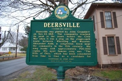
Deersville was platted by John Cramblett on Nov. 25, 1815. The community reached its peak in the years before the Civil War when it was a stop on the stagecoach route between Wheeling and Wooster. Alexander Auld, a songwriter, lived near the community in the 19th century. His song books sold approximately 700,000 copies. His most famous song was "The Hills of Ohio," which has been considered from time to time as a candidated for
(Continued on other side)
Side B
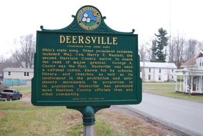
(Continued from other side)
Ohio's state song. Other prominent residents included Maj. Gen. Harry F. Hazlett, the second Harrison County native to reach the rank of major general. George A. Custer was the first. Deersville was once a cultural center, known for its schools, library, and churches, as well as its involvement in the prohibition and anti-slavery movements. In proportion to its population, Deersville has produced more Harrison County officials than any other community.
Erected 2001 by Scenic Byway Task Force.
Topics. This historical marker is listed in this topic list: Notable Places. A significant historical month for this entry is October 1782.
Location. 40° 18.466′ N,
this page online

Regionally, this marker is in the American Midwest, in Appalachia, and specifically in Northern Appalachia. Globally, it is in North America, the Western Hemisphere, the Western World, and the Anglosphere. Historically, it finds itself in what was once the Haudenosaunee (Iroquois) Confederacy, the territory of the Mississippian Culture, and the Northwest Territory.
Other nearby markers. At least 8 other markers are within 4 miles of this marker, measured as the crow flies: The Moravian Trail (within shouting distance of this marker); Hazel's House (about 700 feet away, measured in a direct line); Moravian House (approx. 0.2 miles away); Mary L. Jobe Akeley / Harry F. Hazlett (approx. ¼ mile away); Tappan (approx. 2.3 miles away); Laceyville (approx. 3.2 miles away); a different marker also named Tappan (approx. 3.4 miles away); The Seven Ranges
Photographed by Mike Wintermantel, December 21, 2014
2. Deersville Marker
Photographed by Mike Wintermantel, December 21, 2014
3. Deersville Marker
Photographed by Mike Wintermantel, December 21, 2014
4. Deersville Marker
Credits. This page was last revised on June 16, 2016. It was originally submitted on December 21, 2014, by Mike Wintermantel of Pittsburgh, Pennsylvania. This page has been viewed 1,599 times since then and 86 times this year. Photos: 1, 2, 3, 4. submitted on December 21, 2014, by Mike Wintermantel of Pittsburgh, Pennsylvania.
