Georgetown in Kings County, Prince Edward Island — The Atlantic Provinces (North America)
Georgetown’s New Railway Station
Nouvelle gare ferroviaire de Georgetown

Photographed By Barry Swackhamer, July 10, 2014
1. Georgetown’s New Railway Station Marker
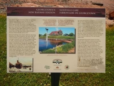
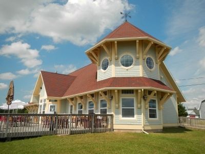
Captions (English / French): With over 400 km of paths, Prince Edward Island’s Confederation Trail is a wonderful way to explore our beautiful Island. / Le Sentier de la Confédération est composé de plus de 400 km de pistes cyclables qui vous mèneront d’un bout à l’autre de la province.; Replica Georgetown Railway Station. / Réplique gare ferroviaire de Georgetown.; DGS Minto at Railway Wharf. / Le DGS Minto au quai ferroviaire.
The railway and the steamship lines serving Prince Edward Island became major drivers to a new industry which became known as tourism. Realizing soon after the railway was open for service in 1875 that more and more of their passengers were visitors from neighbouring provinces and New England, they began to promote the virtues of the Island. Many of the visitors were ex-patriots but many were not. The bulk of the traffic occurred in the non-winter months, just as now.
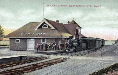
Railway buildings were sturdy utilitarian structures distinctive but never attractive. The turn of the 20th century seemed to mark a turning point. Georgetown got a beautiful new architect-designed station in 1903. It was located at the intersection of the head of the Railway Wharf and the Montague Ferry Wharf. A second-storey, hexagonal pagoda-style viewing room overlooked both ferry routes. Painted light green with white trim, it was intended as an attractive first impression for visitors entering the scenic natural harbour. The structure did not survive after passenger service ceased in the 1960s but a full-scale replica, opened in 2006 was built as a symbol of Georgetown’s history as a regional transportation hub. Interpretation panels are located inside.
French:
Les voies ferroviaires et navigables qui desservent l’Île-du-Prince-Édouard sont devenues les principaux catalyseurs d’une nouvelle industrie, connue sous le nom de tourisme. En réalisant pue après l’ouverture de la gare ferroviaire en 1875 qu’un nombre croissant de passagers étaient de visiteurs des provinces voisines et de la Nouvelle-Angleterre, la compagnie a commencé à promouvoir les vertus de l’Île. De nombreux visiteurs étaient de ex-patriotes, mais de nombreux autres ne l’étaient pas La majeure partie des visiteurs évitaient les mois d’hiver pour se rendre sur l’Île, tout comme maintenant.
Les bâtiments ferroviaires étaient de solides constructions utilitaires, distinctive mais loin d’être attrayantes. L’arrivée du 20ᵉ siècle a semblé marquer un point tournant. En 1903, la gare de Georgetown a été transformée en magnifique gare au design architectural. Elle était située à l’intersection de la tête du quai ferroviaire et du quai de traversier de Montague. Un amphithéâtre hexagonal à deux étages de style pagode surplombait de deux voies. Peint en vert pâle agrémenté de boiseries blanches, l’édifice avait été conçu pour attirer au premier coup d’oeil les visiteurs qui arrivaient dans ce pittoresque port naturel. La structure n’a pas survécu à l’interruption du trafic voyageur dans les années 1960, mais une réplique à l’échelle réelle, ouverte en 2006, a été construite pour symboliser l’historie de Georgetown à titre de plaque tournante de transport régional. On trouve des panneaux d’interpretation à l’intérieur du bâtiment.
Erected by Trans Canada Trail & Prince Edward Island.
Topics. This historical marker is listed in this topic list: Railroads & Streetcars. A significant historical year for this entry is 1875.
Location. 46° 10.825′ N, 62° 32.319′ W. Marker is in Georgetown, Prince Edward Island, in Kings County. Marker is on Richmond Street close to West Street, on the left when traveling west. Touch for map. Marker is at or near this postal address: 2 Richmond Street, Georgetown PE C0A 1L0, Canada. Touch for directions.
Other nearby markers. At least 8 other markers are within 21 kilometers of this marker, measured as the crow flies. Three Rivers (a few steps from this marker); The Honorable Andrew Archibald (A.A.) Macdonald (approx. 0.6 kilometers away); Georgetown War Memorial (approx. 0.6 kilometers away); The Fishery at Murray Harbour / La Pêche À Murray Harbour (approx. 19.5 kilometers away); Cape Bear Lighthouse / Phare de Cape Bear (approx. 19.5 kilometers away); Getting the Train to the Track / L’Arrivée du Train sur la Voie Ferrée (approx. 19.5 kilometers away); The “Harbour” / Le « Harbour » (approx. 19.6 kilometers away); The Murray Harbour Branch / L’Embranchement Menant À Murray Harbour (approx. 19.6 kilometers away). Touch for a list and map of all markers in Georgetown.
More about this marker. This marker is located near the boat ramp.
Credits. This page was last revised on June 16, 2016. It was originally submitted on January 15, 2015, by Barry Swackhamer of Brentwood, California. This page has been viewed 457 times since then and 18 times this year. Photos: 1, 2, 3, 4, 5. submitted on January 15, 2015, by Barry Swackhamer of Brentwood, California. • Andrew Ruppenstein was the editor who published this page.


