Queenstown in Queen Anne's County, Maryland — The American Northeast (Mid-Atlantic)
British Command
Star-Spangled Banner National Historic Trail
— War of 1812 —
Inscription.
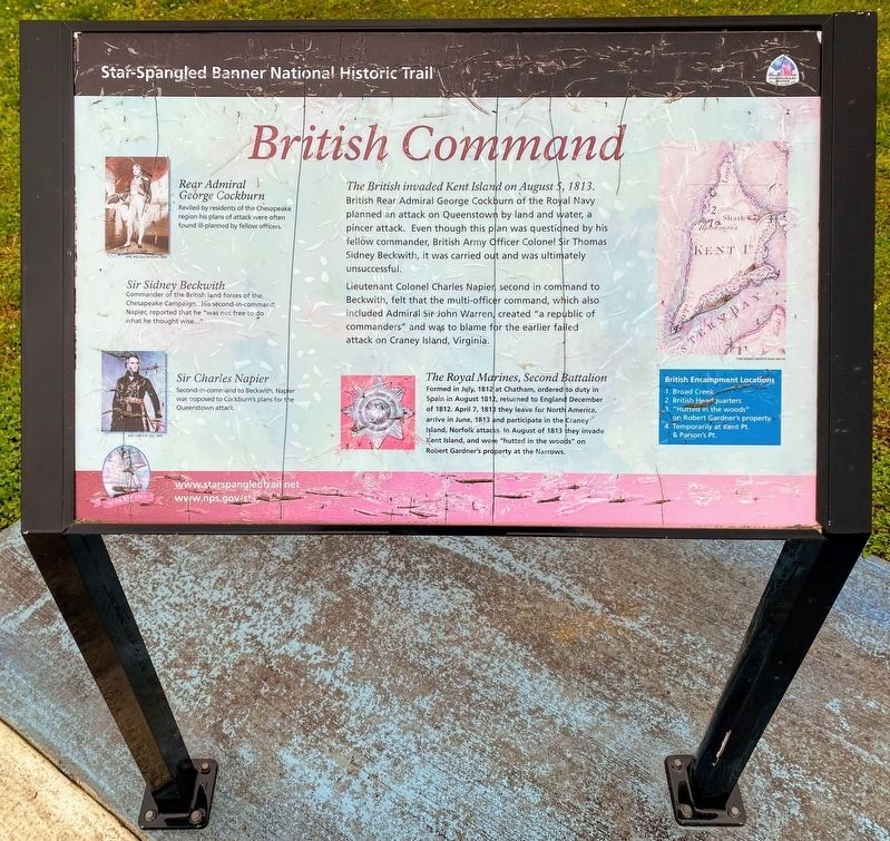
The British invaded Kent Island on August 5, 1813. British Rear Admiral George Cockburn of the Royal Navy planned an attack on Queenstown by land and water, a pincer attack. Even though this plan was questioned by his fellow commander, British Army Officer Colonel Sir Thomas Sidney Beckwith, it was carried out and was ultimately unsuccessful.
Lieutenant Colonel Charles Napier, second in command to Beckwith, felt that the multi-officer command, which also included Admiral Sir John Warren, created “a republic of commanders” and was to blame for the earlier failed attack on Craney Island, Virginia.
The Royal Marines
Second Battalion formed in July, 1812 at Chatham, ordered to duty in Spain in August 1812, returned to England December of 1812. April 7, 1813 they leave for North America, arrive in June, 1813 and participate in the Craney Island, Norfolk attacks, in August of 1813 they invade Kent Island, and were “hutted in the woods” on Robert Gardner’s property at the Narrows.
[Captions:]
Rear Admiral George Cockburn-Reviled by residents of the Chesapeake region his plans of attack were often found ill-planned by fellow officers.
Sir Sidney Beckwith-Commander of the British land forces of the Chesapeake Campaign. His second-in-command, Napier, reported that he “was not free to do what he thought wise…”
Sir Charles Napier-Second-in-command to Beckwith, Napier was opposed to Cockburn’s plans for the Queenstown attack.
Erected by National Park Service, U.S. Department of the Interior.
Topics and series. This historical marker is listed in this topic list: War of 1812. In addition, it is included in the Star Spangled Banner National Historic Trail series list. A significant historical date for this entry is April 18, 1814.
Location. 38° 57.931′ N, 76° 10.917′ W. Marker is in Queenstown, Maryland, in Queen Anne's County. Marker is on Main Street. Touch for map. Marker is in this post office area: Queenstown MD 21658, United States of America. Touch for directions.
Other nearby markers. At least 8 other markers are within 2 miles of this marker, measured as the crow flies. The Battle Enjoined! (here, next to this marker); Protecting the Homefront (here, next to this marker); The Men Who Stood and Fought at Slippery Hill (here, next to this marker); Lure of Freedom (within shouting distance of this marker); Battle of Slippery Hill (approx. 0.4 miles away); Road to Battle (approx. half a mile away); Governor William Grason (approx. 1.1 miles away); US M60 "Patton" Tank (approx. 1.3 miles away). Touch for a list and map of all markers in Queenstown.
Credits. This page was last revised on April 16, 2024. It was originally submitted on February 7, 2015, by Don Morfe of Baltimore, Maryland. This page has been viewed 529 times since then and 23 times this year. Photos: 1. submitted on December 27, 2022, by Shane Oliver of Richmond, Virginia. 2, 3, 4. submitted on February 7, 2015, by Don Morfe of Baltimore, Maryland. • Bill Pfingsten was the editor who published this page.


