Haute-Ville in Québec in Communauté-Urbaine-de-Québec, — Central Canada (French-Canadian)
Joseph Bouchette
1774-1841
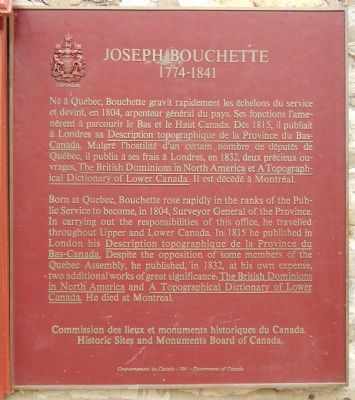
Born at Quebec, Bouchette rose rapidly in the ranks of the Public Service to become, in 1804, Surveyor General of the Province. In carrying out the responsibilities of this office, he travelled throughout Upper and Lower Canada. In 1815 he published in London his Description topographique de la Province du Bas-Canada. Despite the opposition of some members of the Quebec Assembly, he published, in 1832, at his own expense, two additional works of great significance, The British Dominions in North American and A Topographical Dictionary of Lower Canada. He died in Montréal.
French:
Né à Québec, Bouchette gravit rapidement les échelons du service et devint, en 1804, arpenteur général du pays. Ses fonctions l'amenèrent à parcourir le Bas et le Haut Canada. Dès 1815, il publiait à Londres sa Description topographique de la Province du Bas-Canada. Malgré l'hostilité d'un certain nombre de députés, de Québec, il publia à ses frais à Londres, en 1832, deux précieux ouvrages, The British Dominions in North America et A Topographical Dictionary of Lower Canada. Il est décédé à Montréal.
Erected 1941 by Historic Sites and Monument Board of Canada/Commission de lieux et monuments historique du Canada.
Topics and series. This historical marker is listed in these topic lists: Exploration • Science & Medicine. In addition, it is included in the Canada, Historic Sites and Monuments Board series list. A significant historical year for this entry is 1804.
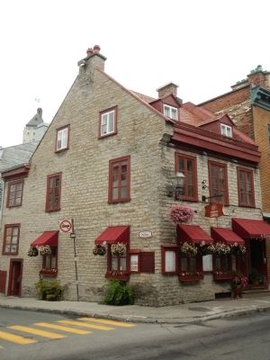
Location. 46° 48.692′ N, 71° 12.468′ W. Marker is in Québec, in Communauté-Urbaine-de-Québec. It is in Haute-Ville. Marker is at the intersection of Rue Saint Louis and Rue du Parloir, on the left when traveling east on Rue Saint Louis. Touch for map. Marker is at or near this postal address: 44 Rue Saint Louis, Québec G1R 4M4, Canada. Touch for directions.
Other nearby markers. At least 8 other markers are within walking distance of this marker. Louis-Joseph de Montcalm (within shouting distance of this marker); The Jacquet House (within shouting distance of this marker); Le Monastère des Ursulines/ The Ursuline Monastery (within shouting distance of this marker); Kent House (within shouting distance of this marker); Stone Wind Mill (about 90 meters away, measured in a direct line); The Maillou House (about 90 meters away); Québec Court House (about 120 meters away); Theatre de l’Estoc (about 120 meters away). Touch for a list and map of all markers in Québec.
More about this marker. This marker is on the Rue du Parloir side of the building.
Also see . . . Joseph Bouchette - Dictionary of Canadian Biography. As surveyor general Joseph Bouchette was obviously in a favourable position to develop and publish his material. Nevertheless the synthesis that he produced from his labours, augmented by his personal research, rouses admiration and makes him particularly important for the history and development of Canada. In addition to completely reorganizing surveying and cartographic services in Lower Canada, he published works that demonstrate his artistic and scientific talents. He may also be judged by an impressive number of maps. (Submitted on March 9, 2015, by Barry Swackhamer of Brentwood, California.)
Credits. This page was last revised on February 9, 2023. It was originally submitted on March 9, 2015, by Barry Swackhamer of Brentwood, California. This page has been viewed 356 times since then and 19 times this year. Photos: 1, 2, 3. submitted on March 9, 2015, by Barry Swackhamer of Brentwood, California. • Andrew Ruppenstein was the editor who published this page.


