Washington Square West in Philadelphia in Philadelphia County, Pennsylvania — The American Northeast (Mid-Atlantic)
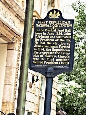
First Republican National Convention
Erected 2000 by Pennsylvania Historical & Museum Commission.
Topics and series. This historical marker is listed in this topic list: Government & Politics. In addition, it is included in the Former U.S. Presidents: #15 James Buchanan, and the Pennsylvania Historical and Museum Commission series lists. A significant historical month for this entry is June 1856.
Location. 39° 56.816′ N, 75° 9.306′ W. Marker is in Philadelphia, Pennsylvania, in Philadelphia County. It is in Washington Square West. Marker is on Locust Street. Touch for map. Marker is at or near this postal address: 808 Locust Street, Philadelphia PA 19107, United States of America. Touch for directions.
Other nearby markers. At least 8 other markers are within walking distance of this marker. Musical Fund Hall 1824 (here, next to this marker); Reynolds-Morris House (within shouting distance of this marker); Joseph Bonaparte (about 400 feet away, measured in a direct line); Haym Salomon (about 400 feet away); Mikveh Israel Cemetery (about 400 feet away); a different marker also named Mikveh Israel Cemetery (about 400 feet away); Cemetery of the Congregation Mikve Israel (about 400 feet away); On This Site (about 400 feet away). Touch for a list and map of all markers in Philadelphia.
Credits. This page was last revised on February 2, 2023. It was originally submitted on March 27, 2015, by Don Morfe of Baltimore, Maryland. This page has been viewed 405 times since then and 17 times this year. Photo 1. submitted on August 16, 2015, by Carolyn Martienssen of West Hazleton, Pennsylvania. • Bill Pfingsten was the editor who published this page.
