Coatepeque, Santa Ana, El Salvador — Central America (West Coast)
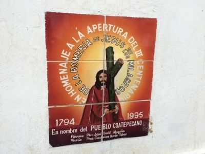
Pilgrimage of Jesus of the Miracles
Romería de Jesús de los Milagros
De la romeria de Jesús de los Milagros
1794 – 1995
En nombre del pueblo coatepequeno
Parroco Pbro. Jose David Magana
Vicario Pbro. Guadalupe Moan Tobar
In tribute to the three hundredth anniversary
Of the Pilgrimage of Jesus of the Miracles
1794 – 1995
In name of the people of Coatepeque
Parish priest Jose David Magana
Vicar Guadalupe Moan Tobar
Erected 1995.
Topics. This historical marker is listed in these topic lists: Churches & Religion • Notable Events. A significant historical year for this entry is 1794.
Location. 13° 55.533′ N, 89° 30.229′ W. Marker is in Coatepeque, Santa Ana. Touch for map. Touch for directions.
Other nearby markers. At least 8 other markers are within 19 kilometers of this marker, measured as the crow flies. Aurelio Fuertes and Santa Ana Cathedral (approx. 9.6 kilometers away); David Granadino (approx. 9.6 kilometers away); Ecological Park "San Lorenzo" (approx. 10.6 kilometers away); Structure 7 at San Andrés Archaeological Site (approx. 18.6 kilometers away in La Libertad); Abandonment of the San Andrés Archaeological Site (approx. 18.7 kilometers away in La Libertad); San Andrés Archaeological Site (approx. 18.7 kilometers away in La Libertad); San Andrés was an extensive prehispanic settlement (approx. 18.7 kilometers away in La Libertad); Indigo Production at San Andrés (approx. 18.9 kilometers away in La Libertad).

Photographed By J. Makali Bruton, March 26, 2015
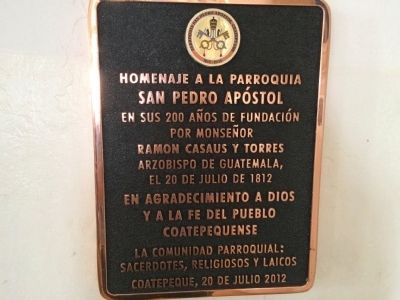
2. Additional marker inside San Pedro Apostol Church
Translated this marker reads: Tribute to the parish of San Pedro Apostol at 200 years since its founding by Monsignor Ramon Casaus y Torres, Archbishop of Guatemala on July 20, 1812 with gratefulness to God and the faith of the Coatepeque people, the parish community, priests and the laity, Coatepeque, July 20, 2012
Credits. This page was last revised on September 13, 2018. It was originally submitted on April 20, 2015, by J. Makali Bruton of Accra, Ghana. This page has been viewed 678 times since then and 11 times this year. Photos: 1, 2, 3, 4, 5. submitted on April 20, 2015, by J. Makali Bruton of Accra, Ghana. • Andrew Ruppenstein was the editor who published this page.


