Coteau-du-Lac in Vaudreuil-Soulanges, Québec — Central Canada (French-Canadian)
A canal excavated in the rock
Un canal creusé dans le roc
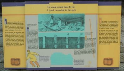
The point at Coteau-du-Lac is formed by superimposed layers of dolomite (rock containing lime and magnesium). The British military used various excavation techniques to build a canal at this spot.
In general, they removed the rock layer by layer by driving iron wedges in between the strata with sledgehammers. In the case of large, un-cracked surfaces, they drilled holes and then partially filled the with gunpowder which was ignited to blast the rock. We also presume that frost action during the winter helped to split the rock and thereby facilitated the excavation work.
How was the rock blasted with gunpowder?
Two men bored a blasting hole in the rock with a jumper and sledgehammer.
A third of the hole was filled with gunpowder into which a long needle was inserted. A small wad of straw was placed above the gunpowder. The hole was then filled with fragments of stone up to within an inch of its top and an iron rod was used to ram the tamping. The top of the hole was sealed off with moist clay. The needle was then pulled out and the small opening left in its place was filled with fine powder or with a series of straws containing powder and acting as a fuse. All that the powderman then had to do was light the charge and run as fast as his legs could carry him before the explosion occurred!
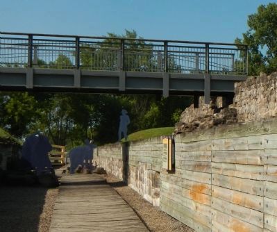
Look carefully at the other side of the canal. You can see traces of the holes made in the bedrock with the boring tools. The diameter of these blasting holes varies from 3 to 4 cm and the deepest ones penetrated the rock up to 60 cm.
French:
La pointe de Coteau-du-lac est formée de dolomie (roche contenant de la chaux et la magnésie) disposée en couches superposées. Pour y construire un canal, les militaires britanniques ont utilisé différentes techniques d’excavation.
Habituellement, ils dégageant une à une les couches rocheuses en y enfonçant les coins de fer a la masse. Pour les grandes surfaces non fissurées, ils introduisaient de la poudre à canon dans les trous percés à même le roc et le faisait ainsi éclater. De plus, on présume qu’au cours de l’hiver le gel a contribué au fractionnement de la roche, facilitant l’autant le travail des ouvriers.
Comment faire exploser le roc á la poudre á canon
Deux hommes perdaient un trou de mine avec un foret et un masse. Dans le premier tiers du trou, on versait de la poudre á canon dans laquelle on introduisait une longue aiguille. Une petite bourre de paille était placée sur la poudre á canon. On mettait ensuite des éclats de pierre, tassés à la barre de fer, jusqu’a un pouce du bord du trou, que l’on comblait avec de l’argile humide. On retirait alors l’aiguille
du trou; le petit orifice laissé par l’aiguille était rempli avec une fine poudre à canon ou encore avec une paille contenant cette substance explosive et qui tenait lieu de mèche. Enfin, il ne restait qu’a allumer et à se sauver le plus vite possible avant l’explosion!
Observez bien l’autre paroi du canal; vous remarquerez dans la roche mère des traces de trou fait au foret, Le diamètre de ces trous variait de trois à quatre centimètres et les plus profonds pénétraient jusqu’a soixante centimètres dans la roche.
Erected by Parks Canada / Parcs Canada.
Topics. This historical marker is listed in these topic lists: Forts and Castles • War of 1812 • Waterways & Vessels.
Location. 45° 17.249′ N, 74° 10.56′ W. Marker is in Coteau-du-Lac, Québec, in Vaudreuil-Soulanges. Marker can be reached from Chemin du Fleuve close to Rue du Fort, on the left when traveling south. Touch for map. Marker is at or near this postal address: 307 Chemin du Fleuve, Coteau-du-Lac QC J0P 1B0, Canada. Touch for directions.
Other nearby markers. At least 8 other markers are within walking distance of this marker. A supply centre / Un poste de ravitaillement (a few steps from this marker); What is a lock canal? (a few steps from this marker); The construction of the canal (a few steps from this marker); A canal that must be preserved (a few steps from this marker); North blockhouse / Le blockhaus nord (within shouting distance of this marker); Adapting the canal to new needs (within shouting distance of this marker); A very busy canal (within shouting distance of this marker); The first lock canal in North America (within shouting distance of this marker). Touch for a list and map of all markers in Coteau-du-Lac.
More about this marker. This marker is located at Coteau-du-Lac National Historic Site.
Credits. This page was last revised on January 23, 2022. It was originally submitted on May 29, 2015, by Barry Swackhamer of Brentwood, California. This page has been viewed 393 times since then and 9 times this year. Photos: 1, 2. submitted on May 29, 2015, by Barry Swackhamer of Brentwood, California. • Andrew Ruppenstein was the editor who published this page.

